Herdorf night lights from space
Night Light of Herdorf (Rheinland-Pfalz) from space (Germany) Src. Average luminocity for 10x10km area is 2.2759% and for 50x50km: 2.5084%.
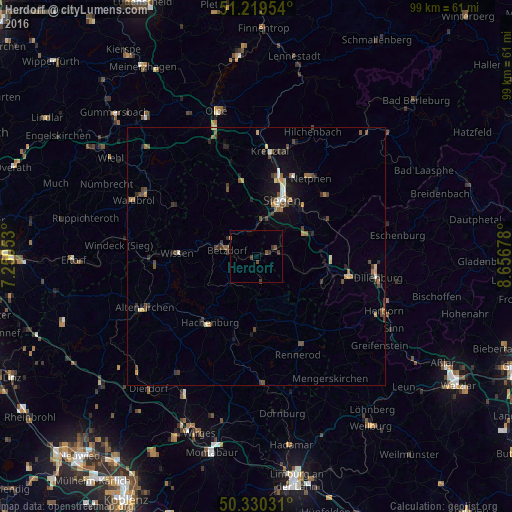
Analysis of Herdorf night lights 2016
Square area 10x10 km:
 0%
0%90-99
0%80-89
0%70-79
0%60-69
0%50-59
0.42%40-49
1.54%30-39
2.1%20-29
0.42%10-19
0%0-9
95.52%Square area 50x50 km:
0.12%90-99
0.23%80-89
0.25%70-79
0.32%60-69
0.3%50-59
0.44%40-49
0.76%30-39
0.63%20-29
0.51%10-19
1.3%0-9
95.14%Clear (daylight) street map image can be seen on geolist.org.
Map coordinates:
51° 13' 10.3" North, 7° 15' 1.9" East
50° 46' 37.3" North, 7° 57' 13.2" East
50° 19' 49.1" North, 8° 39' 24.4" East
Some cities around Herdorf sort by population:
• Siegen
11.9 km =7.4 mi,  24°
24°
• Wilnsdorf
11.2 km =7 mi,  66°
66°
• Burbach
9.3 km =5.8 mi,  108°
108°
• Neunkirchen
4.1 km =2.5 mi,  51°
51°
• Betzdorf
6 km =3.7 mi,  285°
285°
• Kirchen
5.9 km =3.7 mi,  306°
306°
• Mudersbach
5.4 km =3.4 mi,  352°
352°
• Niederfischbach
10.2 km =6.3 mi,  323°
323°
2906143 (p: 7,239)
Sources (retrieved 2019-11-25):
» Earth at Night: Flat Maps 2012, 2016