Grassau night lights from space
Night Light of Grassau (Bavaria) from space (Germany) Src. Average luminocity for 10x10km area is 0.6935% and for 50x50km: 1.6898%.
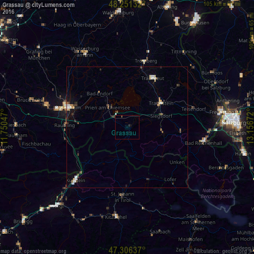
Analysis of Grassau night lights 2016
Square area 10x10 km:
 0%
0%90-99
0%80-89
0%70-79
0%60-69
0%50-59
0.15%40-49
0.45%30-39
0%20-29
0.6%10-19
1.19%0-9
97.62%Square area 50x50 km:
0.24%90-99
0.22%80-89
0.19%70-79
0.13%60-69
0.16%50-59
0.24%40-49
0.22%30-39
0.32%20-29
0.32%10-19
0.73%0-9
97.22%Clear (daylight) street map image can be seen on geolist.org.
Map coordinates:
48° 15' 4.8" North, 11° 45' 1.7" East
47° 46' 51.6" North, 12° 27' 12.9" East
47° 18' 22.9" North, 13° 9' 24.2" East
Some cities around Grassau sort by population:
• Traunstein
17.2 km =10.7 mi,  55°
55°
• Prien am Chiemsee
11.6 km =7.2 mi,  316°
316°
• Siegsdorf
14.9 km =9.3 mi,  71°
71°
• Bad Endorf
18.4 km =11.4 mi, 320°
• Bernau am Chiemsee
6.7 km =4.2 mi,  300°
300°
• Ruhpolding
14.8 km =9.2 mi,  96°
96°
• Aschau im Chiemgau
9.8 km =6.1 mi,  267°
267°
• Riedering
19.4 km =12.1 mi,  289°
289°
2917978 (p: 6,323)
Sources (retrieved 2019-11-25):
» Earth at Night: Flat Maps 2012, 2016