Goslar night lights from space
Night Light of Goslar (Lower Saxony) from space (Germany) Src. Average luminocity for 10x10km area is 11.8548% and for 50x50km: 2.2052%.
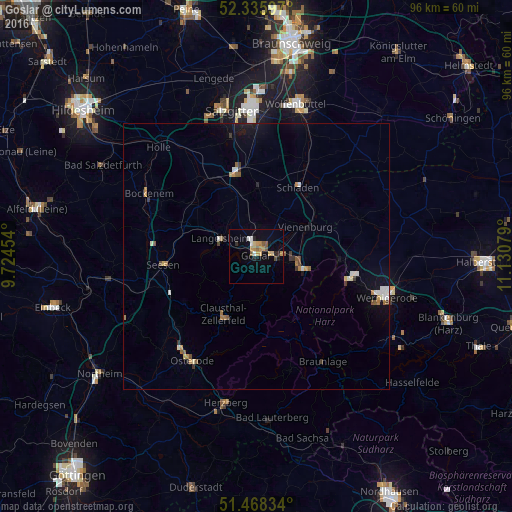

Analysis of Goslar night lights 2016
Square area 10x10 km:
 1.26%
1.26%90-99
0.76%80-89
1.39%70-79
3.54%60-69
1.26%50-59
2.27%40-49
0.63%30-39
0%20-29
2.53%10-19
2.4%0-9
83.96%Square area 50x50 km:
0.2%90-99
0.38%80-89
0.12%70-79
0.38%60-69
0.31%50-59
0.37%40-49
0.14%30-39
0.27%20-29
0.16%10-19
1.02%0-9
96.67%Clear (daylight) street map image can be seen on geolist.org.
Map coordinates:
52° 20' 9.5" North, 9° 43' 28.3" East
51° 54' 15.3" North, 10° 25' 39.6" East
51° 28' 6" North, 11° 7' 50.8" East
Some cities around Goslar sort by population:
• Bad Harzburg
9.5 km =5.9 mi,  104°
104°
• Seesen
17.2 km =10.7 mi,  265°
265°
• Clausthal-Zellerfeld
12.2 km =7.6 mi,  210°
210°
• Langelsheim
7.5 km =4.7 mi,  299°
299°
• Vienenburg
10.8 km =6.7 mi,  60°
60°
• Liebenburg
13.1 km =8.1 mi,  1°
1°
• Ilsenburg
17.7 km =11 mi, 103°
• Schladen
15.2 km =9.4 mi,  30°
30°
2918840 (p: 43,560)
Sources (retrieved 2019-11-25):
» Earth at Night: Flat Maps 2012, 2016