Glinde night lights from space
Night Light of Glinde (Schleswig-Holstein) from space (Germany) Src. Average luminocity for 10x10km area is 41.3532% and for 50x50km: 22.4138%.
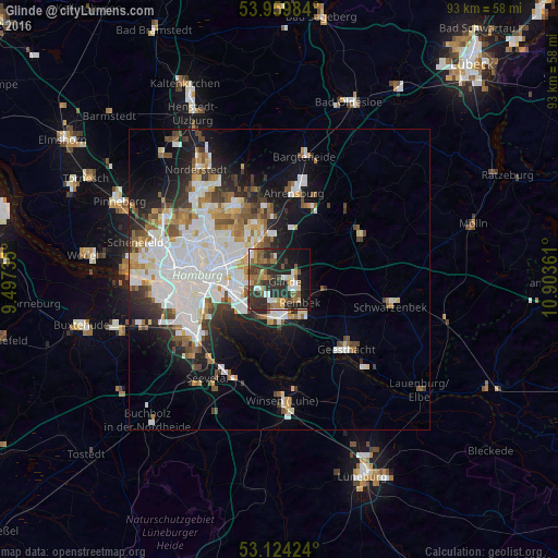
Analysis of Glinde night lights 2016
Square area 10x10 km:
 6.08%
6.08%90-99
4.76%80-89
3.84%70-79
3.84%60-69
6.48%50-59
10.45%40-49
5.69%30-39
8.47%20-29
25%10-19
18.78%0-9
6.61%Square area 50x50 km:
7.01%90-99
5.07%80-89
1.51%70-79
1.82%60-69
2.39%50-59
2.2%40-49
2.59%30-39
2.3%20-29
4.29%10-19
8.86%0-9
61.96%Clear (daylight) street map image can be seen on geolist.org.
Map coordinates:
53° 57' 35.4" North, 9° 29' 50.5" East
53° 32' 38.8" North, 10° 12' 1.7" East
53° 7' 27.3" North, 10° 54' 13" East
Some cities around Glinde sort by population:
• Wandsbek
8.9 km =5.5 mi,  299°
299°
• Marienthal
8.1 km =5 mi,  287°
287°
• Bergedorf
6.9 km =4.3 mi,  164°
164°
• Farmsen-Berne
8.7 km =5.4 mi,  322°
322°
• Reinbek
4.4 km =2.7 mi,  133°
133°
• Barsbüttel
3.4 km =2.1 mi, 318°
• Wentorf bei Hamburg
5.9 km =3.7 mi,  146°
146°
• Oststeinbek
2.1 km =1.3 mi,  267°
267°
2919880 (p: 16,210)
Sources (retrieved 2019-11-25):
» Earth at Night: Flat Maps 2012, 2016