Forbach night lights from space
Night Light of Forbach (Baden-Württemberg) from space (Germany) Src. Average luminocity for 10x10km area is 1.5283% and for 50x50km: 7.56%.
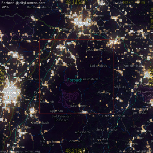
Analysis of Forbach night lights 2016
Square area 10x10 km:
 0%
0%90-99
0%80-89
0.3%70-79
0%60-69
0%50-59
0.6%40-49
0.6%30-39
0%20-29
0.3%10-19
1.19%0-9
97.02%Square area 50x50 km:
0.73%90-99
0.94%80-89
0.65%70-79
1.01%60-69
0.97%50-59
1.06%40-49
1.15%30-39
0.9%20-29
1.35%10-19
7.83%0-9
83.41%Clear (daylight) street map image can be seen on geolist.org.
Map coordinates:
49° 8' 43.5" North, 7° 38' 48.7" East
48° 40' 60" North, 8° 21' 0" East
48° 13' 1.1" North, 9° 3' 11.2" East
Some cities around Forbach sort by population:
• Baden-Baden
11.8 km =7.3 mi,  316°
316°
• Gaggenau
13 km =8.1 mi,  354°
354°
• Bühl
15.8 km =9.8 mi,  275°
275°
• Gernsbach
9.7 km =6 mi,  356°
356°
• Sinzheim
16.3 km =10.1 mi,  304°
304°
• Bad Wildbad
16.5 km =10.3 mi,  62°
62°
• Bühlertal
11.8 km =7.3 mi,  271°
271°
• Bad Herrenalb
14.2 km =8.8 mi,  26°
26°
2925924 (p: 5,477)
Sources (retrieved 2019-11-25):
» Earth at Night: Flat Maps 2012, 2016