Bad Herrenalb night lights from space
Night Light of Bad Herrenalb (Baden-Württemberg) from space (Germany) Src. Average luminocity for 10x10km area is 2.1506% and for 50x50km: 12.8631%.
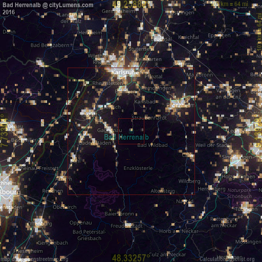
Analysis of Bad Herrenalb night lights 2016
Square area 10x10 km:
 0%
0%90-99
0%80-89
0%70-79
0.57%60-69
0%50-59
0%40-49
1.14%30-39
0.57%20-29
0.57%10-19
0%0-9
97.16%Square area 50x50 km:
1.37%90-99
1.95%80-89
1%70-79
1.45%60-69
1.63%50-59
1.95%40-49
1.91%30-39
1.97%20-29
3.06%10-19
13.45%0-9
70.26%Clear (daylight) street map image can be seen on geolist.org.
Map coordinates:
49° 15' 32" North, 7° 43' 58.9" East
48° 47' 52.3" North, 8° 26' 10.2" East
48° 19' 57.3" North, 9° 8' 21.4" East
Some cities around Bad Herrenalb sort by population:
• Gaggenau
7.5 km =4.7 mi,  271°
271°
• Gernsbach
7.5 km =4.7 mi,  245°
245°
• Malsch
12.1 km =7.5 mi,  321°
321°
• Bad Wildbad
9.9 km =6.2 mi,  122°
122°
• Neuenbürg
12.8 km =8 mi,  65°
65°
• Kuppenheim
13.7 km =8.5 mi,  284°
284°
• Muggensturm
13.6 km =8.5 mi,  304°
304°
• Forbach
14.2 km =8.8 mi,  206°
206°
2953440 (p: 7,521)
Sources (retrieved 2019-11-25):
» Earth at Night: Flat Maps 2012, 2016