Falkensee night lights from space
Night Light of Falkensee (Brandenburg) from space (Germany) Src. Average luminocity for 10x10km area is 30.9762% and for 50x50km: 25.7603%.
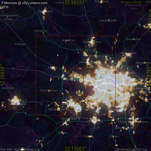

Analysis of Falkensee night lights 2016
Square area 10x10 km:
 0.4%
0.4%90-99
3.17%80-89
4.63%70-79
5.69%60-69
5.03%50-59
7.67%40-49
6.88%30-39
4.63%20-29
8.33%10-19
27.12%0-9
26.46%Square area 50x50 km:
7.74%90-99
6.25%80-89
2.46%70-79
1.77%60-69
2.27%50-59
2.46%40-49
2.7%30-39
2.88%20-29
6.27%10-19
9.23%0-9
55.96%Clear (daylight) street map image can be seen on geolist.org.
Map coordinates:
52° 59' 7.8" North, 12° 23' 22.5" East
52° 33' 36.5" North, 13° 5' 33.7" East
52° 7' 50.2" North, 13° 47' 45" East
Some cities around Falkensee sort by population:
• Staaken
4.7 km =2.9 mi,  123°
123°
• Wilhelmstadt
6.9 km =4.3 mi, 124°
• Spandau
7.3 km =4.5 mi,  97°
97°
• Hakenfelde
7.8 km =4.8 mi,  91°
91°
• Brieselang
6.8 km =4.2 mi,  292°
292°
• Wustermark
9.7 km =6 mi,  263°
263°
• Dallgow-Döberitz
3 km =1.9 mi,  230°
230°
• Konradshöhe
9.5 km =5.9 mi,  72°
72°
2927930 (p: 37,468)
Sources (retrieved 2019-11-25):
» Earth at Night: Flat Maps 2012, 2016