Edenkoben night lights from space
Night Light of Edenkoben (Rheinland-Pfalz) from space (Germany) Src. Average luminocity for 10x10km area is 7.2634% and for 50x50km: 11.5651%.
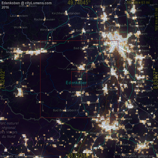
Analysis of Edenkoben night lights 2016
Square area 10x10 km:
 0%
0%90-99
0.53%80-89
0.53%70-79
0.53%60-69
0.67%50-59
0.8%40-49
0.94%30-39
1.6%20-29
2.41%10-19
6.95%0-9
85.03%Square area 50x50 km:
1.8%90-99
1.9%80-89
0.86%70-79
1.02%60-69
1.28%50-59
1.15%40-49
1.66%30-39
1.7%20-29
3.21%10-19
10.41%0-9
75.01%Clear (daylight) street map image can be seen on geolist.org.
Map coordinates:
49° 44' 25.6" North, 7° 25' 26.5" East
49° 17' 2.1" North, 8° 7' 37.7" East
48° 49' 23.3" North, 8° 49' 49" East
Some cities around Edenkoben sort by population:
• Neustadt
7.4 km =4.6 mi,  6°
6°
• Landau in der Pfalz
9.5 km =5.9 mi,  184°
184°
• Haßloch
12.9 km =8 mi,  47°
47°
• Bellheim
14.6 km =9.1 mi,  130°
130°
• Annweiler am Trifels
14 km =8.7 mi,  231°
231°
• Offenbach an der Queich
11.1 km =6.9 mi,  152°
152°
• Lachen-Speyerdorf
7.4 km =4.6 mi, 45°
• Lingenfeld
15.7 km =9.8 mi,  102°
102°
2933410 (p: 6,668)
Sources (retrieved 2019-11-25):
» Earth at Night: Flat Maps 2012, 2016