Isen night lights from space
Night Light of Isen (Bavaria) from space (Germany) Src. Average luminocity for 10x10km area is 1.0149% and for 50x50km: 4.5291%.
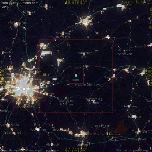
Analysis of Isen night lights 2016
Square area 10x10 km:
 0.6%
0.6%90-99
0%80-89
0%70-79
0%60-69
0.3%50-59
0.3%40-49
0%30-39
0%20-29
0%10-19
0%0-9
98.81%Square area 50x50 km:
0.56%90-99
0.83%80-89
0.4%70-79
0.36%60-69
0.51%50-59
0.46%40-49
0.57%30-39
0.66%20-29
1.28%10-19
3.75%0-9
90.62%Clear (daylight) street map image can be seen on geolist.org.
Map coordinates:
48° 40' 42.3" North, 11° 21' 13" East
48° 12' 43.3" North, 12° 3' 24.2" East
47° 44' 28.8" North, 12° 45' 35.5" East
Some cities around Isen sort by population:
• Erding
15.2 km =9.4 mi,  313°
313°
• Dorfen
10.1 km =6.3 mi,  49°
49°
• Altdorf
11.5 km =7.1 mi,  124°
124°
• Ebersberg
16.3 km =10.1 mi,  203°
203°
• Markt Schwaben
14.1 km =8.8 mi,  259°
259°
• Taufkirchen
16.3 km =10.1 mi,  19°
19°
• Haag in Oberbayern
10.7 km =6.6 mi, 121°
• Moosinning
17.3 km =10.7 mi,  294°
294°
2895702 (p: 5,222)
Sources (retrieved 2019-11-25):
» Earth at Night: Flat Maps 2012, 2016