Altdorf night lights from space
Night Light of Altdorf (Bavaria) from space (Germany) Src. Average luminocity for 10x10km area is 0.2232% and for 50x50km: 1.9002%.
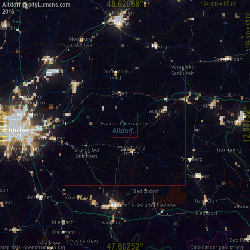
Analysis of Altdorf night lights 2016
Square area 10x10 km:
 0%
0%90-99
0%80-89
0%70-79
0%60-69
0%50-59
0%40-49
0%30-39
0%20-29
0.6%10-19
0%0-9
99.4%Square area 50x50 km:
0.16%90-99
0.31%80-89
0.23%70-79
0.19%60-69
0.24%50-59
0.2%40-49
0.32%30-39
0.4%20-29
0.34%10-19
0.4%0-9
97.2%Clear (daylight) street map image can be seen on geolist.org.
Map coordinates:
48° 37' 14.4" North, 11° 28' 51.9" East
48° 9' 13.5" North, 12° 11' 3.1" East
47° 40' 57.1" North, 12° 53' 14.4" East
Some cities around Altdorf sort by population:
• Waldkraiburg
17 km =10.6 mi,  69°
69°
• Dorfen
13.1 km =8.1 mi,  352°
352°
• Grafing bei München
20 km =12.4 mi,  233°
233°
• Wasserburg am Inn
11.6 km =7.2 mi,  165°
165°
• Ebersberg
18 km =11.2 mi,  241°
241°
• Haag in Oberbayern
1 km =0.6 mi,  338°
338°
• Ampfing
20.4 km =12.7 mi,  56°
56°
• Isen
11.5 km =7.1 mi,  304°
304°
2958032 (p: 11,355)
Sources (retrieved 2019-11-25):
» Earth at Night: Flat Maps 2012, 2016