Brühl night lights from space
Night Light of Brühl (Baden-Württemberg) from space (Germany) Src. Average luminocity for 10x10km area is 42.7714% and for 50x50km: 23.6811%.
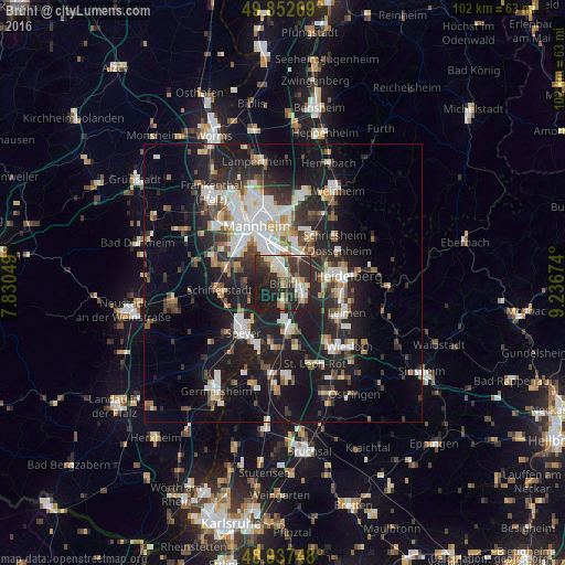
Analysis of Brühl night lights 2016
Square area 10x10 km:
 6.15%
6.15%90-99
8.02%80-89
5.61%70-79
2.81%60-69
4.28%50-59
4.95%40-49
4.68%30-39
12.17%20-29
28.48%10-19
22.86%0-9
0%Square area 50x50 km:
4.36%90-99
4.85%80-89
1.85%70-79
1.76%60-69
2.39%50-59
2.45%40-49
2.81%30-39
3.64%20-29
9.16%10-19
20.33%0-9
46.4%Clear (daylight) street map image can be seen on geolist.org.
Map coordinates:
49° 51' 9.7" North, 7° 49' 49.8" East
49° 23' 50" North, 8° 32' 1" East
48° 56' 14.9" North, 9° 14' 12.3" East
Some cities around Brühl sort by population:
• Schwetzingen
3.9 km =2.4 mi,  115°
115°
• Hockenheim
8.3 km =5.2 mi,  170°
170°
• Eppelheim
7.5 km =4.7 mi,  85°
85°
• Ketsch
3.3 km =2.1 mi,  183°
183°
• Oftersheim
5 km =3.1 mi,  134°
134°
• Plankstadt
4.5 km =2.8 mi, 93°
• Altrip
5.1 km =3.2 mi,  326°
326°
• Waldsee
6.8 km =4.2 mi,  268°
268°
2943321 (p: 14,262)
Sources (retrieved 2019-11-25):
» Earth at Night: Flat Maps 2012, 2016