Altrip night lights from space
Night Light of Altrip (Rheinland-Pfalz) from space (Germany) Src. Average luminocity for 10x10km area is 63.7983% and for 50x50km: 25.2759%.
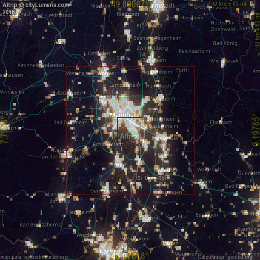
Analysis of Altrip night lights 2016
Square area 10x10 km:
 18.63%
90-99
19.05%80-89
6.16%70-79
4.48%60-69
3.08%50-59
7%40-49
6.44%30-39
14.01%20-29
14.29%10-19
6.86%0-9
0%Square area 50x50 km:
4.73%90-99
5.26%80-89
2.09%70-79
1.91%60-69
2.62%50-59
2.59%40-49
3%30-39
3.61%20-29
9.57%10-19
21.08%0-9
43.55%Clear (daylight) street map image can be seen on geolist.org.
Map coordinates:
49° 53' 26.4" North, 7° 47' 29.8" East
49° 26' 8" North, 8° 29' 41" East
48° 58' 34.2" North, 9° 11' 52.3" East
Some cities around Altrip sort by population:
• Mannheim
6.3 km =3.9 mi,  341°
341°
• Ludwigshafen am Rhein
6.2 km =3.9 mi,  325°
325°
• Gartenstadt
7.1 km =4.4 mi,  291°
291°
• Brühl
5.1 km =3.2 mi,  146°
146°
• Limburgerhof
7.5 km =4.7 mi,  260°
260°
• Ilvesheim
6.8 km =4.2 mi,  50°
50°
• Neuhofen
5.1 km =3.2 mi, 260°
• Waldsee
6 km =3.7 mi,  221°
221°
2956891 (p: 7,802)
Sources (retrieved 2019-11-25):
» Earth at Night: Flat Maps 2012, 2016