Bitterfeld-Wolfen night lights from space
Night Light of Bitterfeld-Wolfen (Saxony-Anhalt) from space (Germany) Src. Average luminocity for 10x10km area is 25.2326% and for 50x50km: 7.4624%.
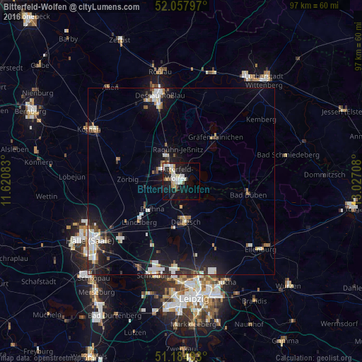
Analysis of Bitterfeld-Wolfen night lights 2016
Square area 10x10 km:
 5.35%
5.35%90-99
6.42%80-89
2.67%70-79
2.01%60-69
3.07%50-59
1.34%40-49
1.07%30-39
0.27%20-29
4.14%10-19
28.21%0-9
45.45%Square area 50x50 km:
1.44%90-99
1.54%80-89
0.58%70-79
0.44%60-69
0.73%50-59
0.7%40-49
0.68%30-39
0.71%20-29
2.07%10-19
6.49%0-9
84.62%Clear (daylight) street map image can be seen on geolist.org.
Map coordinates:
52° 3' 28.7" North, 11° 37' 15" East
51° 37' 24.8" North, 12° 19' 26.2" East
51° 11' 5.7" North, 13° 1' 37.5" East
Some cities around Bitterfeld-Wolfen sort by population:
• Dessau
24.5 km =15.2 mi,  347°
347°
• Wolfen
5.7 km =3.5 mi,  317°
317°
• Delitzsch
11 km =6.8 mi,  173°
173°
• Schkeuditz
26.2 km =16.3 mi,  195°
195°
• Eilenburg
28.1 km =17.5 mi,  130°
130°
• Bad Düben
18.4 km =11.4 mi,  101°
101°
• Gräfenhainichen
14.9 km =9.3 mi,  37°
37°
• Sandersdorf
4.1 km =2.5 mi,  277°
277°
2948164 (p: 15,608)
Sources (retrieved 2019-11-25):
» Earth at Night: Flat Maps 2012, 2016