Bargteheide night lights from space
Night Light of Bargteheide (Schleswig-Holstein) from space (Germany) Src. Average luminocity for 10x10km area is 10.2765% and for 50x50km: 17.6728%.
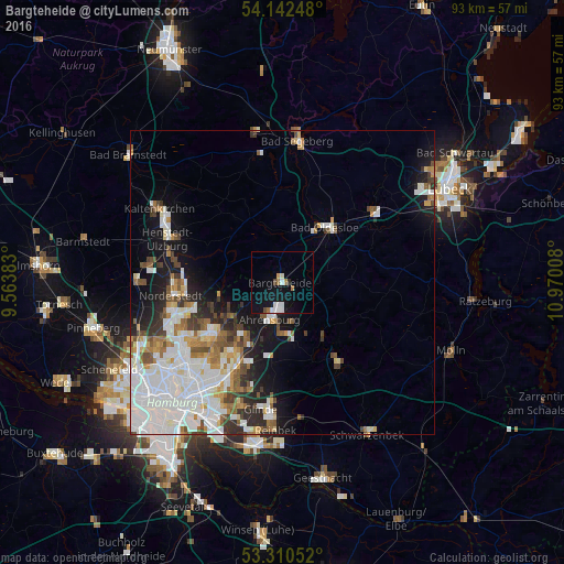
Analysis of Bargteheide night lights 2016
Square area 10x10 km:
 2.78%
2.78%90-99
1.77%80-89
0%70-79
0.51%60-69
1.89%50-59
0.13%40-49
1.01%30-39
0%20-29
0.51%10-19
12.5%0-9
78.91%Square area 50x50 km:
5.93%90-99
4.26%80-89
1.05%70-79
1.4%60-69
1.85%50-59
1.65%40-49
1.94%30-39
1.5%20-29
2.45%10-19
6.77%0-9
71.2%Clear (daylight) street map image can be seen on geolist.org.
Map coordinates:
54° 8' 32.9" North, 9° 33' 49.8" East
53° 43' 42.8" North, 10° 16' 1" East
53° 18' 37.9" North, 10° 58' 12.3" East
Some cities around Bargteheide sort by population:
• Ahrensburg
6.5 km =4 mi,  204°
204°
• Bad Oldesloe
11.6 km =7.2 mi,  37°
37°
• Sasel
13.2 km =8.2 mi,  230°
230°
• Bergstedt
11.2 km =7 mi,  235°
235°
• Großhansdorf
7 km =4.3 mi,  171°
171°
• Lemsahl-Mellingstedt
12 km =7.5 mi,  249°
249°
• Duvenstedt
10.9 km =6.8 mi,  257°
257°
• Tangstedt
12.1 km =7.5 mi,  272°
272°
2952633 (p: 13,640)
Sources (retrieved 2019-11-25):
» Earth at Night: Flat Maps 2012, 2016