Balve night lights from space
Night Light of Balve (North Rhine-Westphalia) from space (Germany) Src. Average luminocity for 10x10km area is 0.6667% and for 50x50km: 8.5597%.
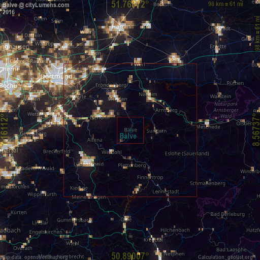
Analysis of Balve night lights 2016
Square area 10x10 km:
 0%
0%90-99
0%80-89
0%70-79
0%60-69
0%50-59
0%40-49
0.56%30-39
0%20-29
0.56%10-19
0.56%0-9
98.32%Square area 50x50 km:
0.72%90-99
0.95%80-89
0.71%70-79
1.05%60-69
1.4%50-59
1.64%40-49
1.66%30-39
1.31%20-29
2%10-19
6.96%0-9
81.6%Clear (daylight) street map image can be seen on geolist.org.
Map coordinates:
51° 46' 7.4" North, 7° 9' 40" East
51° 19' 53.4" North, 7° 51' 51.3" East
50° 53' 24.3" North, 8° 34' 2.5" East
Some cities around Balve sort by population:
• Iserlohn
12.2 km =7.6 mi,  293°
293°
• Menden
13.8 km =8.6 mi,  334°
334°
• Hemer
9 km =5.6 mi,  313°
313°
• Sundern
9.7 km =6 mi,  92°
92°
• Plettenberg
13.6 km =8.5 mi,  177°
177°
• Altena
13.9 km =8.6 mi,  252°
252°
• Werdohl
10.5 km =6.5 mi,  220°
220°
• Neuenrade
7.9 km =4.9 mi,  226°
226°
2953003 (p: 12,281)
Sources (retrieved 2019-11-25):
» Earth at Night: Flat Maps 2012, 2016