Bad Sooden-Allendorf night lights from space
Night Light of Bad Sooden-Allendorf (Hesse) from space (Germany) Src. Average luminocity for 10x10km area is 0.0686% and for 50x50km: 1.0218%.
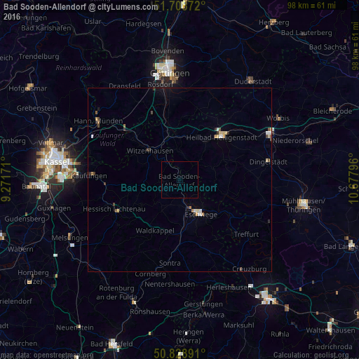
Analysis of Bad Sooden-Allendorf night lights 2016
Square area 10x10 km:
 0%
0%90-99
0%80-89
0%70-79
0%60-69
0%50-59
0%40-49
0%30-39
0%20-29
0%10-19
0%0-9
100%Square area 50x50 km:
0.1%90-99
0.14%80-89
0.21%70-79
0.1%60-69
0.12%50-59
0.1%40-49
0.2%30-39
0.14%20-29
0.13%10-19
0.09%0-9
98.67%Clear (daylight) street map image can be seen on geolist.org.
Map coordinates:
51° 42' 31.4" North, 9° 16' 18.2" East
51° 16' 15.3" North, 9° 58' 29.4" East
50° 49' 44.1" North, 10° 40' 40.7" East
Some cities around Bad Sooden-Allendorf sort by population:
• Eschwege
11.1 km =6.9 mi,  150°
150°
• Heilbad Heiligenstadt
16.4 km =10.2 mi,  43°
43°
• Witzenhausen
11.4 km =7.1 mi,  313°
313°
• Hessisch Lichtenau
19.5 km =12.1 mi,  246°
246°
• Friedland
17 km =10.6 mi,  346°
346°
• Gemeinde Friedland
16.5 km =10.3 mi, 349°
• Großalmerode
13.3 km =8.3 mi,  264°
264°
• Waldkappel
15.6 km =9.7 mi,  205°
205°
2953336 (p: 8,915)
Sources (retrieved 2019-11-25):
» Earth at Night: Flat Maps 2012, 2016