Bad Sachsa night lights from space
Night Light of Bad Sachsa (Lower Saxony) from space (Germany) Src. Average luminocity for 10x10km area is 0.2246% and for 50x50km: 1.8637%.
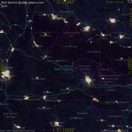
Analysis of Bad Sachsa night lights 2016
Square area 10x10 km:
 0%
0%90-99
0%80-89
0%70-79
0%60-69
0%50-59
0%40-49
0.4%30-39
0.13%20-29
0%10-19
0%0-9
99.47%Square area 50x50 km:
0.21%90-99
0.27%80-89
0.14%70-79
0.27%60-69
0.34%50-59
0.31%40-49
0.17%30-39
0.23%20-29
0.22%10-19
1.09%0-9
96.75%Clear (daylight) street map image can be seen on geolist.org.
Map coordinates:
52° 1' 46.8" North, 9° 51' 8.4" East
51° 35' 42" North, 10° 33' 19.7" East
51° 9' 21.9" North, 11° 15' 30.9" East
Some cities around Bad Sachsa sort by population:
• Nordhausen
19.6 km =12.2 mi,  121°
121°
• Duderstadt
22.4 km =13.9 mi,  246°
246°
• Herzberg am Harz
16.4 km =10.2 mi,  294°
294°
• Bad Lauterberg im Harz
7.2 km =4.5 mi,  305°
305°
• Bleicherode
17.2 km =10.7 mi,  176°
176°
• Ellrich
7.5 km =4.7 mi,  97°
97°
• Worbis
23.6 km =14.7 mi,  214°
214°
• Braunlage
15.1 km =9.4 mi,  14°
14°
2953364 (p: 8,244)
Sources (retrieved 2019-11-25):
» Earth at Night: Flat Maps 2012, 2016