Bad Orb night lights from space
Night Light of Bad Orb (Hesse) from space (Germany) Src. Average luminocity for 10x10km area is 1.1778% and for 50x50km: 2.2196%.
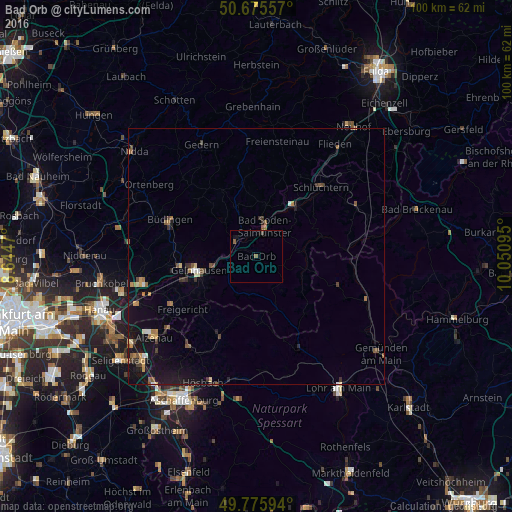
Analysis of Bad Orb night lights 2016
Square area 10x10 km:
 0%
0%90-99
0%80-89
0%70-79
0%60-69
0%50-59
1.07%40-49
0.53%30-39
0%20-29
0%10-19
1.07%0-9
97.33%Square area 50x50 km:
0.1%90-99
0.15%80-89
0.23%70-79
0.24%60-69
0.36%50-59
0.52%40-49
0.31%30-39
0.4%20-29
0.3%10-19
2.5%0-9
94.89%Clear (daylight) street map image can be seen on geolist.org.
Map coordinates:
50° 40' 32.1" North, 8° 38' 40.9" East
50° 13' 40.4" North, 9° 20' 52.2" East
49° 46' 33.4" North, 10° 3' 3.4" East
Some cities around Bad Orb sort by population:
• Gelnhausen
11.8 km =7.3 mi,  255°
255°
• Büdingen
18.2 km =11.3 mi,  292°
292°
• Schlüchtern
18.4 km =11.4 mi,  43°
43°
• Hain-Gründau
14.7 km =9.1 mi,  276°
276°
• Bad Soden-Salmünster
5.5 km =3.4 mi,  14°
14°
• Wächtersbach
4.8 km =3 mi,  309°
309°
• Steinau an der Straße
12.6 km =7.8 mi, 40°
• Birstein
14 km =8.7 mi,  345°
345°
2953384 (p: 10,186)
Sources (retrieved 2019-11-25):
» Earth at Night: Flat Maps 2012, 2016