Hain-Gründau night lights from space
Night Light of Hain-Gründau (Hesse) from space (Germany) Src. Average luminocity for 10x10km area is 6.3717% and for 50x50km: 6.3511%.
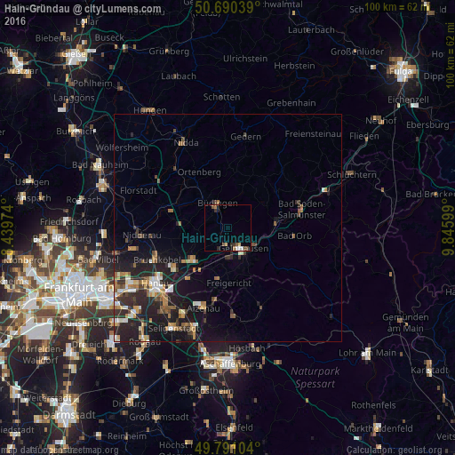
Analysis of Hain-Gründau night lights 2016
Square area 10x10 km:
 0.27%
0.27%90-99
1.34%80-89
1.07%70-79
0%60-69
1.07%50-59
1.6%40-49
0.94%30-39
1.2%20-29
1.07%10-19
1.07%0-9
90.37%Square area 50x50 km:
0.55%90-99
0.94%80-89
0.53%70-79
0.72%60-69
1.12%50-59
1.04%40-49
0.62%30-39
1.12%20-29
2.74%10-19
5.62%0-9
84.99%Clear (daylight) street map image can be seen on geolist.org.
Map coordinates:
50° 41' 25.4" North, 8° 26' 23.1" East
50° 14' 34.2" North, 9° 8' 34.3" East
49° 47' 27.7" North, 9° 50' 45.6" East
Some cities around Hain-Gründau sort by population:
• Gelnhausen
5.6 km =3.5 mi,  145°
145°
• Büdingen
5.7 km =3.5 mi,  336°
336°
• Erlensee
14.7 km =9.1 mi,  232°
232°
• Langenselbold
10.4 km =6.5 mi,  224°
224°
• Wächtersbach
10.9 km =6.8 mi,  82°
82°
• Rodenbach
12.9 km =8 mi, 217°
• Bad Orb
14.7 km =9.1 mi,  96°
96°
• Ortenberg
14 km =8.7 mi,  333°
333°
2911825 (p: 14,723)
Sources (retrieved 2019-11-25):
» Earth at Night: Flat Maps 2012, 2016