Bad Blankenburg night lights from space
Night Light of Bad Blankenburg (Thuringia) from space (Germany) Src. Average luminocity for 10x10km area is 11.4198% and for 50x50km: 2.7412%.
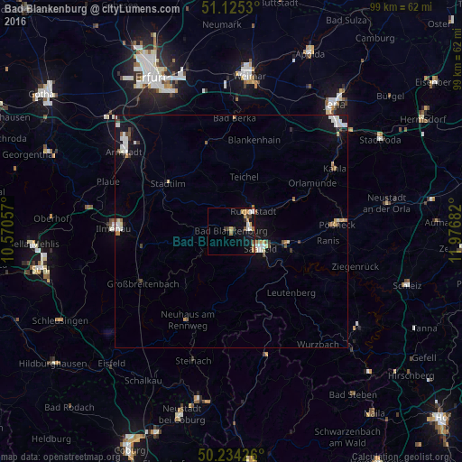
Analysis of Bad Blankenburg night lights 2016
Square area 10x10 km:
 1.47%
1.47%90-99
1.2%80-89
0.94%70-79
3.21%60-69
2.01%50-59
0.94%40-49
0.53%30-39
2.27%20-29
0.53%10-19
8.42%0-9
78.48%Square area 50x50 km:
0.47%90-99
0.58%80-89
0.15%70-79
0.36%60-69
0.29%50-59
0.27%40-49
0.25%30-39
0.23%20-29
0.08%10-19
1.98%0-9
95.32%Clear (daylight) street map image can be seen on geolist.org.
Map coordinates:
51° 7' 31.1" North, 10° 34' 14.1" East
50° 40' 54.8" North, 11° 16' 25.3" East
50° 14' 3.3" North, 11° 58' 36.6" East
Some cities around Bad Blankenburg sort by population:
• Saalfeld
7.5 km =4.7 mi,  120°
120°
• Rudolstadt
6.4 km =4 mi,  47°
47°
• Pößneck
22.5 km =14 mi,  86°
86°
• Blankenhain
20.4 km =12.7 mi,  14°
14°
• Neuhaus am Rennweg
21.4 km =13.3 mi,  206°
206°
• Neuhaus
24 km =14.9 mi,  270°
270°
• Königsee
12.6 km =7.8 mi,  259°
259°
• Stadtilm
17 km =10.6 mi,  307°
307°
2953541 (p: 7,625)
Sources (retrieved 2019-11-25):
» Earth at Night: Flat Maps 2012, 2016