Bad Bentheim night lights from space
Night Light of Bad Bentheim (Lower Saxony) from space (Germany) Src. Average luminocity for 10x10km area is 3.1553% and for 50x50km: 7.7107%.
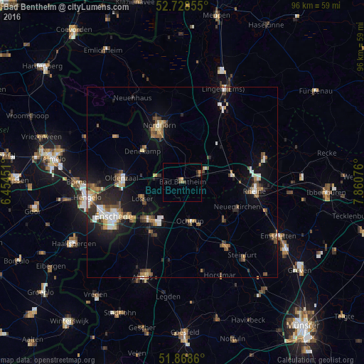
Analysis of Bad Bentheim night lights 2016
Square area 10x10 km:
 0%
0%90-99
0%80-89
0%70-79
0.88%60-69
0.63%50-59
0.51%40-49
1.77%30-39
0.38%20-29
0.76%10-19
0.88%0-9
94.19%Square area 50x50 km:
0.94%90-99
1.12%80-89
0.67%70-79
0.75%60-69
1.03%50-59
1.24%40-49
1.19%30-39
1.12%20-29
2.01%10-19
5.1%0-9
84.84%Clear (daylight) street map image can be seen on geolist.org.
Map coordinates:
52° 43' 42.8" North, 6° 27' 16.2" East
52° 18' 2.4" North, 7° 9' 27.5" East
51° 52' 7" North, 7° 51' 38.7" East
Some cities around Bad Bentheim sort by population:
• Gronau
13.6 km =8.5 mi,  222°
222°
• Oldenzaal, NL
15.6 km =9.7 mi,  275°
275°
• Losser, NL
11.3 km =7 mi,  247°
247°
• Ochtrup
10.5 km =6.5 mi,  167°
167°
• Schüttorf
5 km =3.1 mi,  60°
60°
• Emsbüren
14.7 km =9.1 mi,  41°
41°
• Wettringen
15 km =9.3 mi,  132°
132°
• Salzbergen
13.6 km =8.5 mi,  74°
74°
2953552 (p: 15,508)
Sources (retrieved 2019-11-25):
» Earth at Night: Flat Maps 2012, 2016