Gartenstadt night lights from space
Night Light of Gartenstadt (Rheinland-Pfalz) from space (Germany) Src. Average luminocity for 10x10km area is 61.2227% and for 50x50km: 25.4806%.
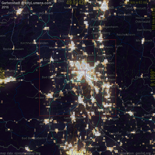
Analysis of Gartenstadt night lights 2016
Square area 10x10 km:
 18.21%
90-99
16.81%80-89
2.66%70-79
6.72%60-69
5.46%50-59
6.72%40-49
6.44%30-39
12.18%20-29
16.95%10-19
7.84%0-9
0%Square area 50x50 km:
4.75%90-99
5.32%80-89
2.08%70-79
1.93%60-69
2.55%50-59
2.57%40-49
3.1%30-39
3.58%20-29
9.63%10-19
21.14%0-9
43.36%Clear (daylight) street map image can be seen on geolist.org.
Map coordinates:
49° 54' 51.3" North, 7° 42' 2.3" East
49° 27' 33.7" North, 8° 24' 13.6" East
49° 0' 0.8" North, 9° 6' 24.8" East
Some cities around Gartenstadt sort by population:
• Mannheim
5.6 km =3.5 mi,  54°
54°
• Ludwigshafen am Rhein
3.9 km =2.4 mi, 51°
• Mutterstadt
4 km =2.5 mi,  239°
239°
• Limburgerhof
4 km =2.5 mi,  192°
192°
• Altrip
7.1 km =4.4 mi,  111°
111°
• Neuhofen
3.8 km =2.4 mi,  156°
156°
• Dannstadt-Schauernheim
7.2 km =4.5 mi,  252°
252°
• Waldsee
7.6 km =4.7 mi, 159°
8642860 (p: 17,745)
Sources (retrieved 2019-11-25):
» Earth at Night: Flat Maps 2012, 2016