Limburgerhof night lights from space
Night Light of Limburgerhof (Rheinland-Pfalz) from space (Germany) Src. Average luminocity for 10x10km area is 37.615% and for 50x50km: 25.7208%.
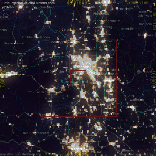
Analysis of Limburgerhof night lights 2016
Square area 10x10 km:
 4.41%
4.41%90-99
6.28%80-89
2.67%70-79
5.21%60-69
4.14%50-59
7.09%40-49
5.21%30-39
10.03%20-29
14.71%10-19
31.95%0-9
8.29%Square area 50x50 km:
4.75%90-99
5.32%80-89
2.25%70-79
1.93%60-69
2.62%50-59
2.52%40-49
3.15%30-39
3.68%20-29
9.46%10-19
21.63%0-9
42.7%Clear (daylight) street map image can be seen on geolist.org.
Map coordinates:
49° 52' 46.8" North, 7° 41' 19.8" East
49° 25' 28" North, 8° 23' 31" East
48° 57' 53.9" North, 9° 5' 42.3" East
Some cities around Limburgerhof sort by population:
• Ludwigshafen am Rhein
7.4 km =4.6 mi,  31°
31°
• Schifferstadt
4.6 km =2.9 mi,  193°
193°
• Gartenstadt
4 km =2.5 mi,  12°
12°
• Mutterstadt
3.2 km =2 mi,  306°
306°
• Altrip
7.5 km =4.7 mi,  80°
80°
• Neuhofen
2.4 km =1.5 mi, 81°
• Dannstadt-Schauernheim
6.3 km =3.9 mi,  286°
286°
• Waldsee
4.8 km =3 mi,  132°
132°
2877647 (p: 10,753)
Sources (retrieved 2019-11-25):
» Earth at Night: Flat Maps 2012, 2016