Otrokovice night lights from space
Night Light of Otrokovice (Zlín) from space (Czech Republic) Src. Average luminocity for 10x10km area is 23.2901% and for 50x50km: 6.1235%.
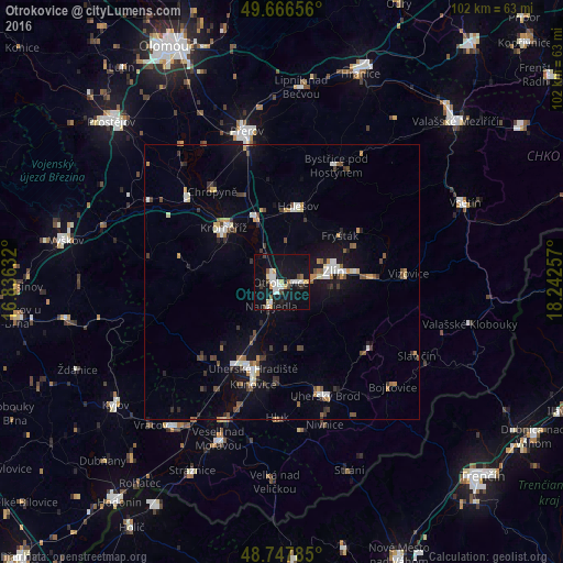
Analysis of Otrokovice night lights 2016
Square area 10x10 km:
 4.55%
4.55%90-99
4.81%80-89
2.27%70-79
1.87%60-69
0.94%50-59
2.14%40-49
2.27%30-39
1.47%20-29
1.74%10-19
34.36%0-9
43.58%Square area 50x50 km:
0.74%90-99
0.89%80-89
0.5%70-79
0.69%60-69
0.51%50-59
0.75%40-49
0.88%30-39
1.02%20-29
0.73%10-19
4.91%0-9
88.37%Clear (daylight) street map image can be seen on geolist.org.
Map coordinates:
49° 39' 59.6" North, 16° 50' 10.8" East
49° 12' 33.6" North, 17° 32' 22" East
48° 44' 52.3" North, 18° 14' 33.3" East
Some cities around Otrokovice sort by population:
• Zlín
9.7 km =6 mi,  78°
78°
• Kroměříž
14.5 km =9 mi,  312°
312°
• Uherské Hradiště
16.6 km =10.3 mi,  200°
200°
• Holešov
14.1 km =8.8 mi,  11°
11°
• Napajedla
4.7 km =2.9 mi,  205°
205°
• Hulín
13.2 km =8.2 mi,  335°
335°
• Staré Město
16.8 km =10.4 mi, 207°
• Kunovice
19 km =11.8 mi, 195°
3068690 (p: 18,857)
Sources (retrieved 2019-11-25):
» Earth at Night: Flat Maps 2012, 2016