Kunovice night lights from space
Night Light of Kunovice (Zlín) from space (Czech Republic) Src. Average luminocity for 10x10km area is 23.2009% and for 50x50km: 5.904%.
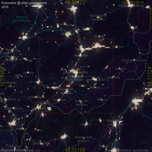
Analysis of Kunovice night lights 2016
Square area 10x10 km:
 3.87%
3.87%90-99
4.46%80-89
1.93%70-79
1.64%60-69
2.53%50-59
3.27%40-49
3.27%30-39
4.02%20-29
1.19%10-19
23.36%0-9
50.45%Square area 50x50 km:
0.76%90-99
0.87%80-89
0.39%70-79
0.5%60-69
0.61%50-59
0.86%40-49
0.84%30-39
0.98%20-29
0.83%10-19
4.91%0-9
88.45%Clear (daylight) street map image can be seen on geolist.org.
Map coordinates:
49° 30' 13.4" North, 16° 46' 1.2" East
49° 2' 42" North, 17° 28' 12.4" East
48° 34' 55.1" North, 18° 10' 23.7" East
Some cities around Kunovice sort by population:
• Uherské Hradiště
2.9 km =1.8 mi,  344°
344°
• Otrokovice
19 km =11.8 mi,  15°
15°
• Uherský Brod
13.1 km =8.1 mi,  99°
99°
• Veselí nad Moravou
12.2 km =7.6 mi,  213°
213°
• Napajedla
14.4 km =8.9 mi,  12°
12°
• Staré Město
4.3 km =2.7 mi,  321°
321°
• Strážnice
19.5 km =12.1 mi, 214°
• Luhačovice
21.8 km =13.5 mi,  73°
73°
3072497 (p: 5,148)
Sources (retrieved 2019-11-25):
» Earth at Night: Flat Maps 2012, 2016