Großschönau night lights from space
Night Light of Großschönau (Saxony) from space (Germany) Src. Average luminocity for 10x10km area is 7.5224% and for 50x50km: 4.5222%.
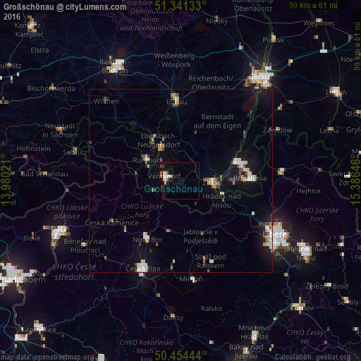
Analysis of Großschönau night lights 2016
Square area 10x10 km:
 1.26%
1.26%90-99
2.66%80-89
0.56%70-79
0.56%60-69
1.26%50-59
0.42%40-49
0%30-39
0.56%20-29
0%10-19
0.7%0-9
92.02%Square area 50x50 km:
0.67%90-99
0.79%80-89
0.3%70-79
0.42%60-69
0.49%50-59
0.62%40-49
0.45%30-39
0.58%20-29
0.56%10-19
3.16%0-9
91.95%Clear (daylight) street map image can be seen on geolist.org.
Map coordinates:
51° 20' 28.8" North, 13° 58' 48.8" East
50° 54' 0" North, 14° 40' 60" East
50° 27' 16" North, 15° 23' 11.3" East
Some cities around Großschönau sort by population:
• Zittau
8.7 km =5.4 mi,  91°
91°
• Varnsdorf, CZ
4.7 km =2.9 mi,  285°
285°
• Rumburk, CZ
10.5 km =6.5 mi,  302°
302°
• Ebersbach
13.8 km =8.6 mi,  330°
330°
• Hrádek nad Nisou, CZ
12.5 km =7.8 mi,  114°
114°
• Neugersdorf
10.1 km =6.3 mi, 328°
• Olbersdorf
6.8 km =4.2 mi,  116°
116°
• Eibau
9.3 km =5.8 mi,  350°
350°
2915067 (p: 6,571)
Sources (retrieved 2019-11-25):
» Earth at Night: Flat Maps 2012, 2016