Geroskipou night lights from space
Night Light of Geroskipou (Pafos) from space (Cyprus) Src. Average luminocity for 10x10km area is 57.3901% and for 50x50km: 7.6557%.
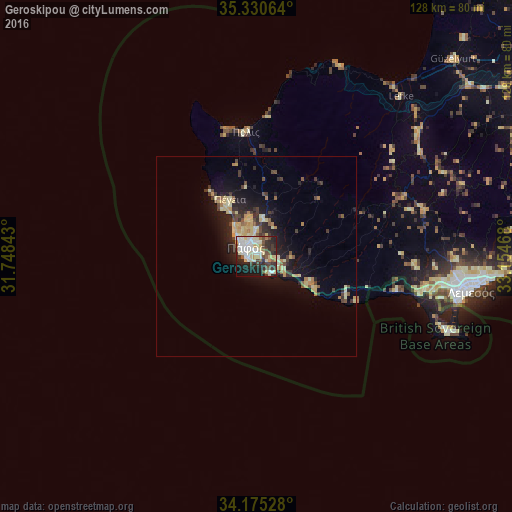
Analysis of Geroskipou night lights 2016
Square area 10x10 km:
100  12.64%
90-99 15.93%
80-89 10.62%
70-79 3.85%
60-69 2.93%
50-59 4.4%
40-49 9.89%
30-39 7.14%
20-29 18.86%
10-19 12.09%
0-9 1.65%
12.64%90-99
15.93%80-89
10.62%70-79
3.85%60-69
2.93%50-59
4.4%40-49
9.89%30-39
7.14%20-29
18.86%10-19
12.09%0-9
1.65%Square area 50x50 km:
100 0.5%
90-99 1.08%
80-89 1.78%
70-79 1.02%
60-69 0.65%
50-59 0.67%
40-49 1.25%
30-39 1.42%
20-29 2.45%
10-19 5.4%
0-9 83.77%
0.5%90-99
1.08%80-89
1.78%70-79
1.02%60-69
0.65%50-59
0.67%40-49
1.25%30-39
1.42%20-29
2.45%10-19
5.4%0-9
83.77%Clear (daylight) street map image can be seen on geolist.org.
Map coordinates:
35° 19' 50.3" North, 31° 44' 54.3" East
34° 45' 17.9" North, 32° 27' 5.6" East
34° 10' 31" North, 33° 9' 16.8" East
Some cities around Geroskipou sort by population:
• Limassol
54.2 km =33.7 mi,  98°
98°
• Paphos
3.5 km =2.2 mi,  314°
314°
• Mórfou
69.8 km =43.4 mi,  45°
45°
• Léfka
53.8 km =33.4 mi,  42°
42°
• Ýpsonas
47.2 km =29.3 mi, 99°
• Dáli
93.4 km =58 mi,  71°
71°
• Tséri
87 km =54.1 mi, 66°
• Lápithos
92.3 km =57.4 mi, 45°
11919534 (p: 8,313)
Sources (retrieved 2019-11-25):
» Earth at Night: Flat Maps 2012, 2016