Livádia night lights from space
Night Light of Livádia (Larnaka) from space (Cyprus) Src. Average luminocity for 10x10km area is 65.2857% and for 50x50km: 18.9191%.
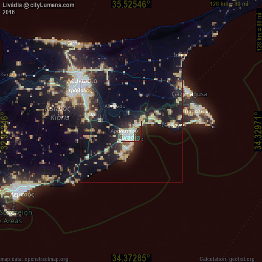
Analysis of Livádia night lights 2016
Square area 10x10 km:
 16.67%
90-99
26.01%80-89
6.96%70-79
3.48%60-69
2.01%50-59
3.85%40-49
8.42%30-39
6.59%20-29
19.41%10-19
6.59%0-9
0%Square area 50x50 km:
1.9%90-99
3.74%80-89
3.55%70-79
2.16%60-69
1.47%50-59
1.4%40-49
2.71%30-39
2.79%20-29
5.77%10-19
15.6%0-9
58.9%Clear (daylight) street map image can be seen on geolist.org.
Map coordinates:
35° 31' 31.7" North, 32° 55' 24.5" East
34° 57' 4.2" North, 33° 37' 35.7" East
34° 22' 22.3" North, 34° 19' 47" East
Some cities around Livádia sort by population:
• Larnaca
3.2 km =2 mi,  185°
185°
• Pérgamos
12.5 km =7.8 mi,  36°
36°
• Aradíppou
3.2 km =2 mi,  270°
270°
• Géri
25.5 km =15.8 mi,  312°
312°
• Dáli
20.3 km =12.6 mi,  293°
293°
• Xylofágou
20.5 km =12.7 mi,  81°
81°
• Tséri
30.8 km =19.1 mi,  296°
296°
• Dhromolaxia
9.2 km =5.7 mi,  203°
203°
146371 (p: 5,329)
Sources (retrieved 2019-11-25):
» Earth at Night: Flat Maps 2012, 2016