Venezuela night lights from space
Night Light of Venezuela (Ciego de Ávila) from space (Cuba) Src. Average luminocity for 10x10km area is 5.5714% and for 50x50km: 3.4357%.
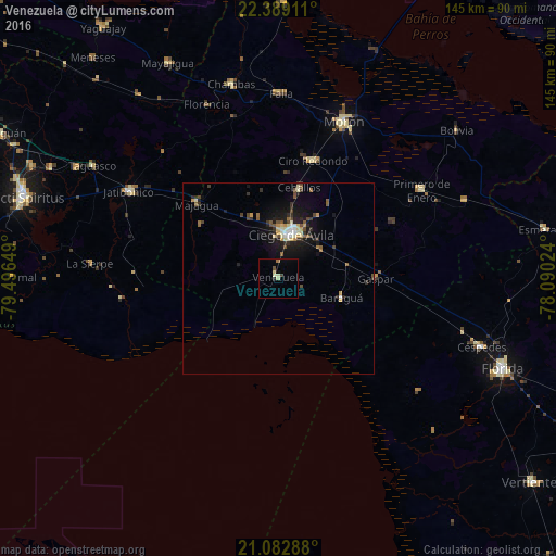
Analysis of Venezuela night lights 2016
Square area 10x10 km:
 0%
0%90-99
0.99%80-89
2.18%70-79
0%60-69
0.79%50-59
0.4%40-49
0.79%30-39
0.4%20-29
0.79%10-19
0%0-9
93.65%Square area 50x50 km:
0.21%90-99
0.52%80-89
0.53%70-79
0.37%60-69
0.2%50-59
0.6%40-49
0.63%30-39
0.62%20-29
0.75%10-19
3.01%0-9
92.57%Clear (daylight) street map image can be seen on geolist.org.
Map coordinates:
22° 23' 20.8" North, 79° 29' 47.4" West
21° 44' 14.9" North, 78° 47' 36.1" West
21° 4' 58.4" North, 78° 5' 24.9" West
Some cities around Venezuela sort by population:
• Ciego de Ávila
11.9 km =7.4 mi,  15°
15°
• Morón
44.6 km =27.7 mi, 22°
• Ciro Redondo
32.7 km =20.3 mi, 16°
• Florencia
49.1 km =30.5 mi,  337°
337°
• Jatibonico
45 km =28 mi,  300°
300°
• Primero de Enero
43.9 km =27.3 mi,  58°
58°
• La Sierpe
49.2 km =30.6 mi,  274°
274°
• Baraguá
18.4 km =11.4 mi,  109°
109°
3534432 (p: 16,601)
Sources (retrieved 2019-11-25):
» Earth at Night: Flat Maps 2012, 2016