Manatí night lights from space
Night Light of Manatí (Las Tunas) from space (Cuba) Src. Average luminocity for 10x10km area is 5.3996% and for 50x50km: 0.7027%.
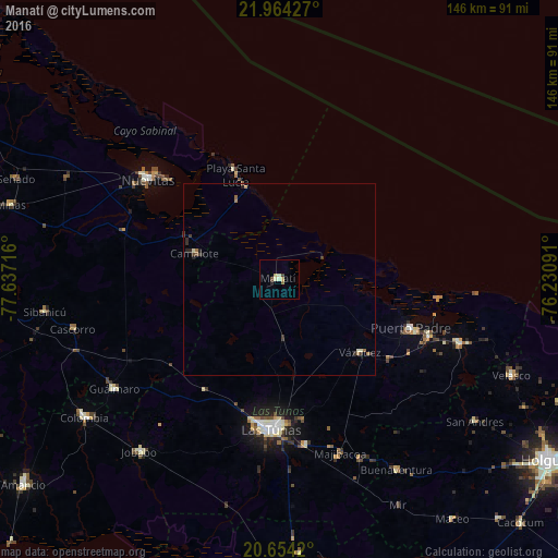
Analysis of Manatí night lights 2016
Square area 10x10 km:
 0%
0%90-99
1.52%80-89
1.14%70-79
1.14%60-69
0.38%50-59
0.57%40-49
1.14%30-39
0.19%20-29
0.76%10-19
0%0-9
93.18%Square area 50x50 km:
0%90-99
0.15%80-89
0.06%70-79
0.1%60-69
0.14%50-59
0.13%40-49
0.08%30-39
0.27%20-29
0.21%10-19
0.1%0-9
98.77%Clear (daylight) street map image can be seen on geolist.org.
Map coordinates:
21° 57' 51.4" North, 77° 38' 13.8" West
21° 18' 38.5" North, 76° 56' 2.5" West
20° 39' 15.1" North, 76° 13' 51.3" West
Some cities around Manatí sort by population:
• Las Tunas
38.8 km =24.1 mi,  182°
182°
• Puerto Padre
36.6 km =22.7 mi,  110°
110°
• Nuevitas
43.1 km =26.8 mi,  307°
307°
• Jesús Menéndez
50 km =31.1 mi, 109°
• Jobabo
57.6 km =35.8 mi,  218°
218°
• Guáimaro
51.8 km =32.2 mi,  236°
236°
• Colombia
62.4 km =38.8 mi,  234°
234°
• Sibanicú
61.9 km =38.5 mi,  262°
262°
3548099 (p: 13,278)
Sources (retrieved 2019-11-25):
» Earth at Night: Flat Maps 2012, 2016