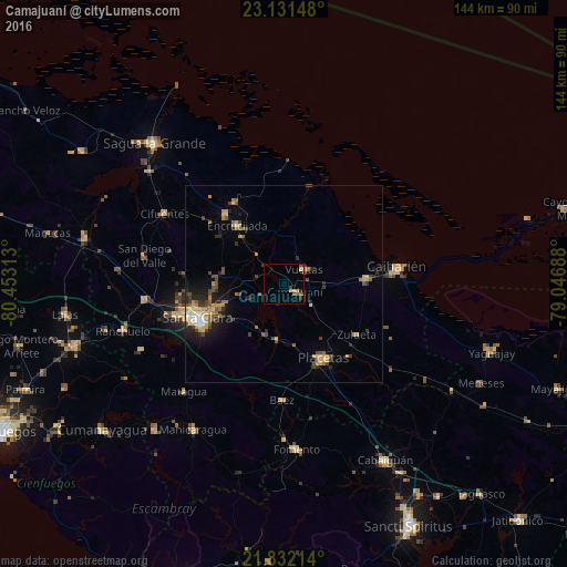
Camajuaní night lights from space
Night Light of Camajuaní (Villa Clara) from space (Cuba) Src. Average luminocity for 10x10km area is 6.6383% and for 50x50km: 5.2245%.

Analysis of Camajuaní night lights 2016
Square area 10x10 km:
 0%
0%90-99
0%80-89
1.52%70-79
1.89%60-69
0%50-59
2.27%40-49
2.08%30-39
0.76%20-29
1.7%10-19
0%0-9
89.77%Square area 50x50 km:
0.22%90-99
0.34%80-89
0.85%70-79
1.12%60-69
0.68%50-59
0.81%40-49
1.27%30-39
0.76%20-29
1.42%10-19
2.24%0-9
90.29%Clear (daylight) street map image can be seen on geolist.org.
Map coordinates:
23° 7' 53.3" North, 80° 27' 11.3" West
22° 28' 60" North, 79° 45' 0" West
21° 49' 55.7" North, 79° 2' 48.8" West
Some cities around Camajuaní sort by population:
• Santa Clara
23.6 km =14.7 mi,  248°
248°
• Placetas
21.5 km =13.4 mi,  152°
152°
• Cifuentes
35.9 km =22.3 mi,  300°
300°
• Caibarién
29.5 km =18.3 mi,  82°
82°
• Remedios
21.1 km =13.1 mi,  86°
86°
• Encrucijada
19.1 km =11.9 mi,  321°
321°
• Esperanza
35.9 km =22.3 mi,  263°
263°
• Calabazar de Sagua
23.4 km =14.5 mi, 320°
3566054 (p: 35,515)
Sources (retrieved 2019-11-25):
» Earth at Night: Flat Maps 2012, 2016