Esperanza night lights from space
Night Light of Esperanza (Villa Clara) from space (Cuba) Src. Average luminocity for 10x10km area is 5.3504% and for 50x50km: 6.8698%.
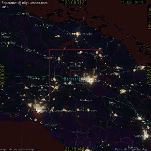
Analysis of Esperanza night lights 2016
Square area 10x10 km:
 0%
0%90-99
0%80-89
1.52%70-79
0.76%60-69
0%50-59
0.76%40-49
0%30-39
1.14%20-29
1.7%10-19
3.03%0-9
91.1%Square area 50x50 km:
0.22%90-99
0.38%80-89
1.27%70-79
1.5%60-69
0.65%50-59
1.03%40-49
1.75%30-39
1.09%20-29
1.95%10-19
3.87%0-9
86.28%Clear (daylight) street map image can be seen on geolist.org.
Map coordinates:
23° 5' 42.4" North, 80° 48' 0.9" West
22° 26' 48.5" North, 80° 5' 49.6" West
21° 47' 43.6" North, 79° 23' 38.4" West
Some cities around Esperanza sort by population:
• Santa Clara
14.3 km =8.9 mi,  108°
108°
• Santo Domingo
21.6 km =13.4 mi,  316°
316°
• Ranchuelo
9.9 km =6.2 mi,  213°
213°
• Cifuentes
23 km =14.3 mi,  12°
12°
• Encrucijada
30.4 km =18.9 mi,  51°
51°
• Cruces
21.3 km =13.2 mi,  236°
236°
• Lajas
20.5 km =12.7 mi,  259°
259°
• Calabazar de Sagua
30.3 km =18.8 mi,  43°
43°
3559235 (p: 10,462)
Sources (retrieved 2019-11-25):
» Earth at Night: Flat Maps 2012, 2016