Bejucal night lights from space
Night Light of Bejucal (Mayabeque) from space (Cuba) Src. Average luminocity for 10x10km area is 42.2619% and for 50x50km: 33.7416%.
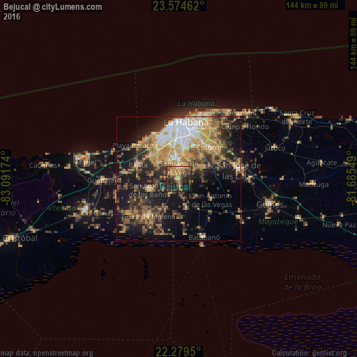
Analysis of Bejucal night lights 2016
Square area 10x10 km:
 0%
0%90-99
0.99%80-89
5.75%70-79
16.87%60-69
6.35%50-59
6.75%40-49
10.52%30-39
10.52%20-29
19.84%10-19
21.43%0-9
0.99%Square area 50x50 km:
3.79%90-99
3.91%80-89
3.41%70-79
9.25%60-69
4.89%50-59
4.61%40-49
7.07%30-39
6.08%20-29
8.28%10-19
18.23%0-9
30.47%Clear (daylight) street map image can be seen on geolist.org.
Map coordinates:
23° 34' 28.6" North, 83° 5' 30.3" West
22° 55' 43" North, 82° 23' 19" West
22° 16' 46.2" North, 81° 41' 7.8" West
Some cities around Bejucal sort by population:
• Diez de Octubre
18 km =11.2 mi,  9°
9°
• Arroyo Naranjo
12.2 km =7.6 mi, 9°
• Boyeros
8.8 km =5.5 mi,  351°
351°
• Bauta
17.3 km =10.7 mi,  290°
290°
• San Antonio de los Baños
12.3 km =7.6 mi,  249°
249°
• Santiago de las Vegas
4.6 km =2.9 mi,  2°
2°
• La Salud
7.2 km =4.5 mi,  209°
209°
• Quivicán
12.2 km =7.6 mi,  163°
163°
3567546 (p: 18,123)
Sources (retrieved 2019-11-25):
» Earth at Night: Flat Maps 2012, 2016