Santiago night lights from space
Night Light of Santiago (San José) from space (Costa Rica) Src. Average luminocity for 10x10km area is 12.0541% and for 50x50km: 19.2887%.
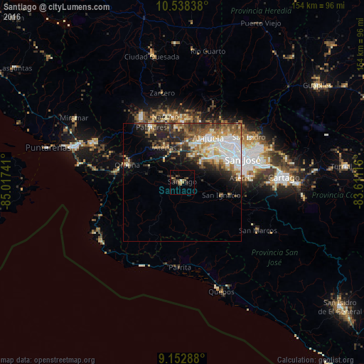
Analysis of Santiago night lights 2016
Square area 10x10 km:
 0%
0%90-99
0.87%80-89
1.08%70-79
1.52%60-69
2.6%50-59
2.81%40-49
2.38%30-39
3.9%20-29
4.33%10-19
0.87%0-9
79.65%Square area 50x50 km:
4.37%90-99
3.57%80-89
2.04%70-79
1.9%60-69
2.71%50-59
2.91%40-49
3.17%30-39
2.93%20-29
4.83%10-19
5.42%0-9
66.15%Clear (daylight) street map image can be seen on geolist.org.
Map coordinates:
10° 32' 18.2" North, 85° 1' 2.7" West
9° 50' 46.9" North, 84° 18' 51.4" West
9° 9' 10.4" North, 83° 36' 40.2" West
Some cities around Santiago sort by population:
• San Rafael Abajo
3.2 km =2 mi,  122°
122°
• San Rafael
21.4 km =13.3 mi,  64°
64°
• Tejar
14.2 km =8.8 mi,  141°
141°
• Escazú
20.7 km =12.9 mi,  67°
67°
• San Antonio
20.9 km =13 mi,  43°
43°
• Colón
11 km =6.8 mi,  46°
46°
• Santa Ana
17.3 km =10.7 mi, 56°
• Atenas
15.9 km =9.9 mi,  333°
333°
3621524 (p: 8,292)
Sources (retrieved 2019-11-25):
» Earth at Night: Flat Maps 2012, 2016