San Vicente de Chucurí night lights from space
Night Light of San Vicente de Chucurí (Santander) from space (Colombia) Src. Average luminocity for 10x10km area is 2.2468% and for 50x50km: 2.4631%.
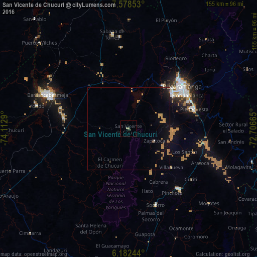
Analysis of San Vicente de Chucurí night lights 2016
Square area 10x10 km:
 0%
0%90-99
0.22%80-89
1.52%70-79
0%60-69
0%50-59
0%40-49
0.22%30-39
1.52%20-29
0%10-19
0%0-9
96.54%Square area 50x50 km:
0.02%90-99
0.03%80-89
0.1%70-79
1.18%60-69
0.68%50-59
0.05%40-49
0.04%30-39
0.23%20-29
0.17%10-19
1.51%0-9
95.98%Clear (daylight) street map image can be seen on geolist.org.
Map coordinates:
7° 34' 42.7" North, 74° 6' 46.4" West
6° 52' 51.6" North, 73° 24' 35.2" West
6° 10' 56.8" North, 72° 42' 23.9" West
Some cities around San Vicente de Chucurí sort by population:
• Bucaramanga
42 km =26.1 mi,  49°
49°
• Floridablanca
41 km =25.5 mi,  60°
60°
• Girón
33.7 km =20.9 mi, 51°
• Piedecuesta
41.5 km =25.8 mi,  73°
73°
• San Gil
46.8 km =29.1 mi,  139°
139°
• Socorro
48.8 km =30.3 mi,  160°
160°
• Lebrija
33.4 km =20.8 mi,  39°
39°
• Zapatoca
17.3 km =10.7 mi,  114°
114°
3668292 (p: 11,265)
Sources (retrieved 2019-11-25):
» Earth at Night: Flat Maps 2012, 2016