Lebrija night lights from space
Night Light of Lebrija (Santander) from space (Colombia) Src. Average luminocity for 10x10km area is 20.1732% and for 50x50km: 9.5765%.
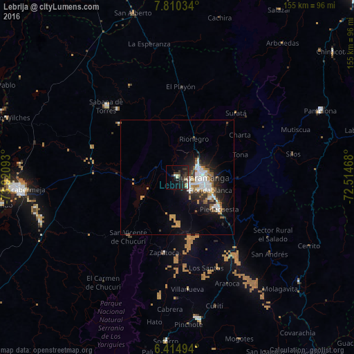
Analysis of Lebrija night lights 2016
Square area 10x10 km:
 2.16%
2.16%90-99
2.6%80-89
2.6%70-79
0.87%60-69
1.3%50-59
0.43%40-49
2.38%30-39
11.47%20-29
8.66%10-19
19.91%0-9
47.62%Square area 50x50 km:
1.95%90-99
1.84%80-89
0.42%70-79
1.6%60-69
0.96%50-59
1.32%40-49
0.4%30-39
1.46%20-29
2.71%10-19
5.77%0-9
81.57%Clear (daylight) street map image can be seen on geolist.org.
Map coordinates:
7° 48' 37.2" North, 73° 55' 15.3" West
7° 6' 47.4" North, 73° 13' 4.1" West
6° 24' 53.8" North, 72° 30' 52.8" West
Some cities around Lebrija sort by population:
• Bucaramanga
10.9 km =6.8 mi,  82°
82°
• Floridablanca
15.6 km =9.7 mi,  111°
111°
• Girón
7.3 km =4.5 mi,  133°
133°
• Piedecuesta
23.2 km =14.4 mi, 126°
• Sabana de Torres
43.6 km =27.1 mi,  315°
315°
• San Vicente de Chucurí
33.4 km =20.8 mi,  219°
219°
• Zapatoca
33.6 km =20.9 mi,  189°
189°
• El Playón
39.9 km =24.8 mi,  2°
2°
3676674 (p: 8,949)
Sources (retrieved 2019-11-25):
» Earth at Night: Flat Maps 2012, 2016