Guaduas night lights from space
Night Light of Guaduas (Cundinamarca) from space (Colombia) Src. Average luminocity for 10x10km area is 4.1983% and for 50x50km: 1.3522%.
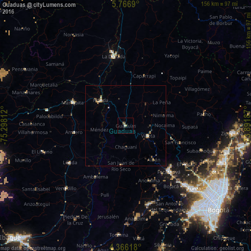
Analysis of Guaduas night lights 2016
Square area 10x10 km:
 0.21%
0.21%90-99
0.62%80-89
0%70-79
1.03%60-69
1.45%50-59
0.83%40-49
0.83%30-39
0.83%20-29
0%10-19
0.41%0-9
93.8%Square area 50x50 km:
0.08%90-99
0.16%80-89
0.12%70-79
0.27%60-69
0.15%50-59
0.35%40-49
0.16%30-39
0.45%20-29
0.12%10-19
0.08%0-9
98.05%Clear (daylight) street map image can be seen on geolist.org.
Map coordinates:
5° 46' 0.8" North, 75° 17' 53.2" West
5° 4' 0.9" North, 74° 35' 42" West
4° 21' 58.2" North, 73° 53' 30.7" West
Some cities around Guaduas sort by population:
• Facatativá
38.8 km =24.1 mi,  136°
136°
• Honda
22.2 km =13.8 mi,  315°
315°
• San Sebastián de Mariquita
36.1 km =22.4 mi,  293°
293°
• Villeta
15 km =9.3 mi,  115°
115°
• Armero-Guyabal
35.9 km =22.3 mi,  251°
251°
• La Vega
29 km =18 mi,  104°
104°
• Anolaima
28 km =17.4 mi,  157°
157°
• Guayabal
32.6 km =20.3 mi,  262°
262°
3681702 (p: 14,392)
Sources (retrieved 2019-11-25):
» Earth at Night: Flat Maps 2012, 2016