Ginebra night lights from space
Night Light of Ginebra (Valle del Cauca) from space (Colombia) Src. Average luminocity for 10x10km area is 11.3506% and for 50x50km: 12.5694%.
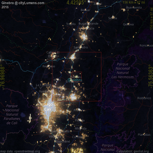
Analysis of Ginebra night lights 2016
Square area 10x10 km:
 0%
0%90-99
0%80-89
0.87%70-79
1.73%60-69
2.6%50-59
2.6%40-49
2.16%30-39
2.38%20-29
2.6%10-19
3.9%0-9
81.17%Square area 50x50 km:
1.17%90-99
1.55%80-89
1.25%70-79
1.27%60-69
2.14%50-59
2.45%40-49
3.05%30-39
2.54%20-29
3.37%10-19
7.1%0-9
74.12%Clear (daylight) street map image can be seen on geolist.org.
Map coordinates:
4° 25' 33.4" North, 76° 58' 11.6" West
3° 43' 28.6" North, 76° 16' 0.3" West
3° 1' 21.8" North, 75° 33' 49.1" West
Some cities around Ginebra sort by population:
• Palmira
21 km =13 mi,  191°
191°
• Guadalajara de Buga
19.9 km =12.4 mi,  350°
350°
• Yumbo
29.5 km =18.3 mi,  237°
237°
• El Cerrito
6.8 km =4.2 mi,  230°
230°
• Guacarí
8.5 km =5.3 mi,  300°
300°
• Restrepo
30.4 km =18.9 mi,  290°
290°
• Yotoco
19.9 km =12.4 mi,  319°
319°
• San Pedro
30.3 km =18.8 mi,  7°
7°
3682039 (p: 6,088)
Sources (retrieved 2019-11-25):
» Earth at Night: Flat Maps 2012, 2016