Restrepo night lights from space
Night Light of Restrepo (Valle del Cauca) from space (Colombia) Src. Average luminocity for 10x10km area is 8.2857% and for 50x50km: 5.9725%.
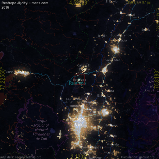
Analysis of Restrepo night lights 2016
Square area 10x10 km:
 0%
0%90-99
1.73%80-89
0.65%70-79
0.22%60-69
1.73%50-59
0%40-49
1.95%30-39
5.41%20-29
0.43%10-19
0.65%0-9
87.23%Square area 50x50 km:
0.24%90-99
0.8%80-89
0.78%70-79
0.5%60-69
1.04%50-59
0.76%40-49
1.12%30-39
0.91%20-29
1.35%10-19
4.71%0-9
87.78%Clear (daylight) street map image can be seen on geolist.org.
Map coordinates:
4° 31' 23.8" North, 77° 13' 32" West
3° 49' 19.3" North, 76° 31' 20.7" West
3° 7' 12.7" North, 75° 49' 9.5" West
Some cities around Restrepo sort by population:
• Guadalajara de Buga
26.4 km =16.4 mi,  70°
70°
• Yumbo
26.9 km =16.7 mi,  172°
172°
• El Cerrito
27.7 km =17.2 mi,  123°
123°
• Guacarí
22 km =13.7 mi,  107°
107°
• Darien
12.9 km =8 mi,  18°
18°
• Dagua
26 km =16.2 mi,  225°
225°
• Yotoco
16 km =9.9 mi, 74°
• Ginebra
30.4 km =18.9 mi, 110°
3670856 (p: 9,545)
Sources (retrieved 2019-11-25):
» Earth at Night: Flat Maps 2012, 2016