San Pedro night lights from space
Night Light of San Pedro (Valle del Cauca) from space (Colombia) Src. Average luminocity for 10x10km area is 14.4177% and for 50x50km: 6.5128%.
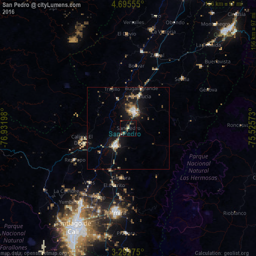
Analysis of San Pedro night lights 2016
Square area 10x10 km:
 0%
0%90-99
0.87%80-89
2.6%70-79
0.87%60-69
3.68%50-59
0.87%40-49
3.25%30-39
4.98%20-29
2.38%10-19
9.31%0-9
71.21%Square area 50x50 km:
0.65%90-99
0.68%80-89
0.74%70-79
0.6%60-69
1.03%50-59
0.95%40-49
1.03%30-39
1.16%20-29
0.91%10-19
6.44%0-9
85.82%Clear (daylight) street map image can be seen on geolist.org.
Map coordinates:
4° 41' 44" North, 76° 55' 55.1" West
3° 59' 40" North, 76° 13' 43.9" West
3° 17' 33.9" North, 75° 31' 32.6" West
Some cities around San Pedro sort by population:
• Tuluá
10.7 km =6.6 mi,  20°
20°
• Guadalajara de Buga
12.9 km =8 mi,  216°
216°
• Guacarí
28.1 km =17.5 mi,  204°
204°
• Andalucía
20.8 km =12.9 mi, 19°
• Bugalagrande
25.5 km =15.8 mi, 18°
• Riofrío
19.3 km =12 mi,  339°
339°
• Yotoco
22.7 km =14.1 mi,  229°
229°
• Trujillo
26.2 km =16.3 mi, 337°
3669156 (p: 5,473)
Sources (retrieved 2019-11-25):
» Earth at Night: Flat Maps 2012, 2016