Carmen de Apicalá night lights from space
Night Light of Carmen de Apicalá (Tolima) from space (Colombia) Src. Average luminocity for 10x10km area is 6.961% and for 50x50km: 6.56%.
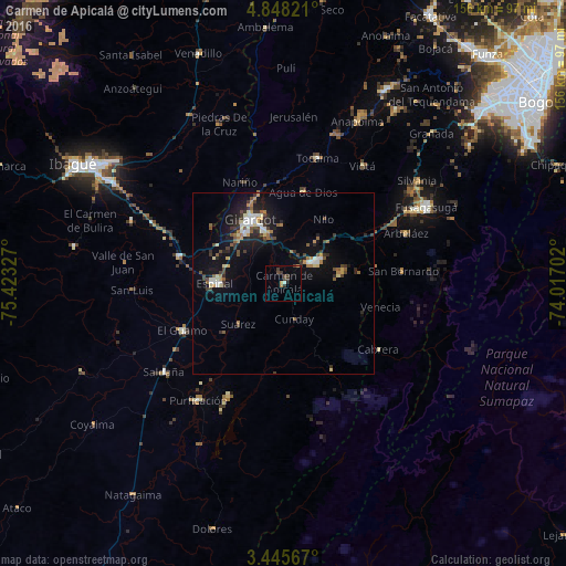
Analysis of Carmen de Apicalá night lights 2016
Square area 10x10 km:
 0.43%
0.43%90-99
0.43%80-89
0%70-79
0.87%60-69
1.3%50-59
0%40-49
3.03%30-39
3.9%20-29
1.3%10-19
0.22%0-9
88.53%Square area 50x50 km:
0.71%90-99
0.82%80-89
0.71%70-79
0.61%60-69
0.76%50-59
0.78%40-49
1.04%30-39
1.51%20-29
1.44%10-19
5.72%0-9
85.9%Clear (daylight) street map image can be seen on geolist.org.
Map coordinates:
4° 50' 53.6" North, 75° 25' 23.8" West
4° 8' 50.1" North, 74° 43' 12.5" West
3° 26' 44.4" North, 74° 1' 1.3" West
Some cities around Carmen de Apicalá sort by population:
• Girardot City
19.6 km =12.2 mi,  330°
330°
• Espinal
18.2 km =11.3 mi,  270°
270°
• Melgar
10.9 km =6.8 mi,  54°
54°
• Flandes
19.1 km =11.9 mi, 326°
• Guamo
30.6 km =19 mi,  244°
244°
• Chicoral
30 km =18.6 mi,  284°
284°
• Agua de Dios
26.1 km =16.2 mi,  12°
12°
• La Chamba
21.2 km =13.2 mi,  230°
230°
3687324 (p: 5,640)
Sources (retrieved 2019-11-25):
» Earth at Night: Flat Maps 2012, 2016