Guantou night lights from space
Night Light of Guantou (Fujian) from space (China) Src. Average luminocity for 10x10km area is 33.1766% and for 50x50km: 25.305%.
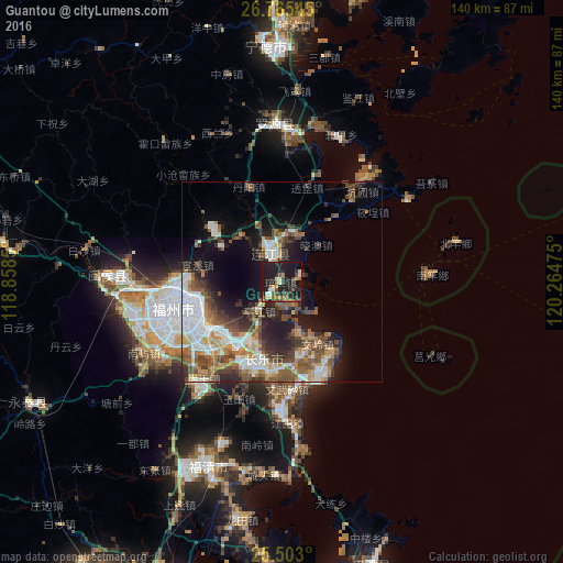
Analysis of Guantou night lights 2016
Square area 10x10 km:
 1.98%
1.98%90-99
3.17%80-89
4.76%70-79
4.76%60-69
2.78%50-59
5.16%40-49
8.33%30-39
3.17%20-29
16.47%10-19
47.42%0-9
1.98%Square area 50x50 km:
5.39%90-99
3.84%80-89
1.84%70-79
3.43%60-69
3.01%50-59
4.55%40-49
5.55%30-39
3.43%20-29
6.08%10-19
11.36%0-9
51.53%Clear (daylight) street map image can be seen on geolist.org.
Map coordinates:
26° 45' 55.6" North, 118° 51' 30.6" East
26° 8' 9.3" North, 119° 33' 41.8" East
25° 30' 10.8" North, 120° 15' 53.1" East
Some cities around Guantou sort by population:
• Fuzhou
26.8 km =16.7 mi,  252°
252°
• Tantou
12.3 km =7.6 mi,  163°
163°
• Dongdai
13.1 km =8.1 mi,  24°
24°
• Dinghaicun
27.8 km =17.3 mi,  54°
54°
• Shangjie
38 km =23.6 mi,  261°
261°
• Rong’an
44 km =27.3 mi,  268°
268°
• Tingjiang
8.9 km =5.5 mi,  219°
219°
• Houyu
8.9 km =5.5 mi,  197°
197°
1809747 (p: 5,790)
Sources (retrieved 2019-11-25):
» Earth at Night: Flat Maps 2012, 2016