Dinghaicun night lights from space
Night Light of Dinghaicun (Fujian) from space (China) Src. Average luminocity for 10x10km area is 1.4464% and for 50x50km: 7.189%.
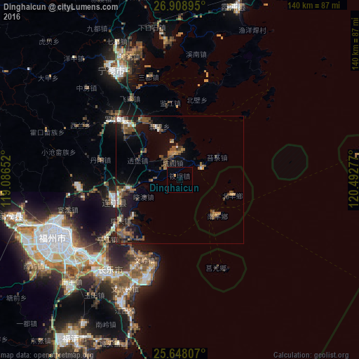
Analysis of Dinghaicun night lights 2016
Square area 10x10 km:
 0%
0%90-99
0%80-89
0%70-79
0%60-69
0.79%50-59
0.4%40-49
0%30-39
0%20-29
0%10-19
0%0-9
98.81%Square area 50x50 km:
0.49%90-99
0.5%80-89
0.46%70-79
0.79%60-69
1.19%50-59
1.54%40-49
2.73%30-39
0.89%20-29
2.16%10-19
5.42%0-9
83.83%Clear (daylight) street map image can be seen on geolist.org.
Map coordinates:
26° 54' 32.2" North, 119° 5' 11.5" East
26° 16' 48.8" North, 119° 47' 22.7" East
25° 38' 53.1" North, 120° 29' 34" East
Some cities around Dinghaicun sort by population:
• Tantou
33.8 km =21 mi,  214°
214°
• Ningde
50 km =31.1 mi,  327°
327°
• Dongdai
17.8 km =11.1 mi,  256°
256°
• Guantou
27.8 km =17.3 mi,  234°
234°
• Jianjiang
30.2 km =18.8 mi,  353°
353°
• Tingjiang
36.4 km =22.6 mi, 231°
• Houyu
35.3 km =21.9 mi, 226°
• Xiahu
40 km =24.9 mi,  23°
23°
1812805 (p: 7,620)
Sources (retrieved 2019-11-25):
» Earth at Night: Flat Maps 2012, 2016