Shangjie night lights from space
Night Light of Shangjie (Fujian) from space (China) Src. Average luminocity for 10x10km area is 76.7341% and for 50x50km: 25.6772%.
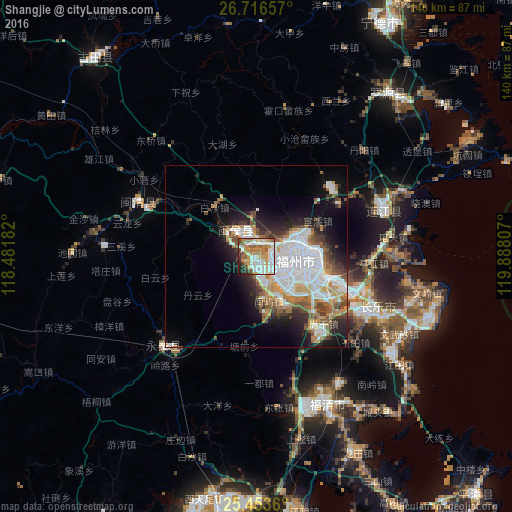
Analysis of Shangjie night lights 2016
Square area 10x10 km:
 21.83%
90-99
20.83%80-89
9.33%70-79
10.91%60-69
14.68%50-59
7.94%40-49
4.17%30-39
3.57%20-29
5.36%10-19
1.39%0-9
0%Square area 50x50 km:
8.01%90-99
4.86%80-89
1.81%70-79
3.26%60-69
3.26%50-59
3.09%40-49
2.76%30-39
2.71%20-29
4.66%10-19
8.22%0-9
57.35%Clear (daylight) street map image can be seen on geolist.org.
Map coordinates:
26° 42' 59.7" North, 118° 28' 54.6" East
26° 5' 12.4" North, 119° 11' 5.8" East
25° 27' 13" North, 119° 53' 17.1" East
Some cities around Shangjie sort by population:
• Fuzhou
12.4 km =7.7 mi,  103°
103°
• Tantou
41.7 km =25.9 mi, 98°
• Fuqing
44.7 km =27.8 mi,  154°
154°
• Dongdai
46.4 km =28.8 mi,  67°
67°
• Guantou
38 km =23.6 mi,  81°
81°
• Rong’an
7.6 km =4.7 mi,  303°
303°
• Tingjiang
32.1 km =19.9 mi,  92°
92°
• Houyu
35.1 km =21.8 mi, 94°
1941784 (p: 7,280)
Sources (retrieved 2019-11-25):
» Earth at Night: Flat Maps 2012, 2016