Duobao night lights from space
Night Light of Duobao (Hubei) from space (China) Src. Average luminocity for 10x10km area is 0% and for 50x50km: 1.5458%.


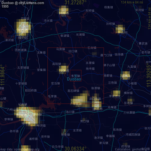
Analysis of Duobao night lights 2016
Square area 10x10 km:
 0%
0%90-99
0%80-89
0%70-79
0%60-69
0%50-59
0%40-49
0%30-39
0%20-29
0%10-19
0%0-9
100%Square area 50x50 km:
0.05%90-99
0.04%80-89
0.1%70-79
0.12%60-69
0.32%50-59
0.35%40-49
0.4%30-39
0.47%20-29
0.65%10-19
0.95%0-9
96.55%Clear (daylight) street map image can be seen on geolist.org.
Map coordinates:
31° 16' 22.3" North, 111° 59' 11" East
30° 40' 12" North, 112° 41' 22.3" East
30° 3' 48" North, 113° 23' 33.5" East
Some cities around Duobao sort by population:
• Shashi
58.7 km =36.5 mi,  226°
226°
• Jingling
39.3 km =24.4 mi,  93°
93°
• Qianjiang
33.8 km =21 mi,  145°
145°
• Jingzhou
59.6 km =37 mi, 233°
• Jingmen
61.4 km =38.2 mi,  311°
311°
• Zhongxiang
56.1 km =34.9 mi,  349°
349°
• Buhe
61.2 km =38 mi, 226°
• Xinshi
60.1 km =37.3 mi,  45°
45°
1811829 (p: 90,257)
Sources (retrieved 2019-11-25):
» NASA, Earths city lights 1995
» NASA city lights 2003
» Earth at Night: Flat Maps 2012, 2016