Chonglong night lights from space
Night Light of Chonglong (Sichuan) from space (China) Src. Average luminocity for 10x10km area is 22.2599% and for 50x50km: 4.1041%.
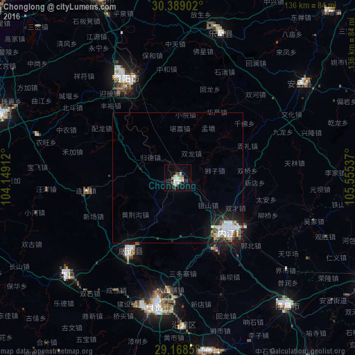
Analysis of Chonglong night lights 2016
Square area 10x10 km:
 5.56%
5.56%90-99
5.16%80-89
1.19%70-79
1.39%60-69
2.58%50-59
2.38%40-49
2.38%30-39
0.4%20-29
1.19%10-19
14.48%0-9
63.29%Square area 50x50 km:
1.03%90-99
0.99%80-89
0.2%70-79
0.23%60-69
0.41%50-59
0.33%40-49
0.55%30-39
0.31%20-29
0.96%10-19
2.65%0-9
92.35%Clear (daylight) street map image can be seen on geolist.org.
Map coordinates:
30° 23' 20.5" North, 104° 8' 56.8" East
29° 46' 50.2" North, 104° 51' 8.1" East
29° 10' 6.6" North, 105° 33' 19.3" East
Some cities around Chonglong sort by population:
• Zigong
49.4 km =30.7 mi,  188°
188°
• Neijiang
29.9 km =18.6 mi,  137°
137°
• Yibin
114.9 km =71.4 mi, 191°
• Leshan
107.9 km =67 mi,  256°
256°
• Suining
106.5 km =66.2 mi,  40°
40°
• Yongchuan
111.4 km =69.2 mi,  115°
115°
• Yanjiang
42.7 km =26.5 mi,  332°
332°
• Luocheng
91 km =56.5 mi,  241°
241°
1814919 (p: 58,441)
Sources (retrieved 2019-11-25):
» NASA, Earths city lights 1995
» NASA city lights 2003
» Earth at Night: Flat Maps 2012, 2016