Villa Presidente Frei, Ñuñoa, Santiago, Chile night lights from space
Night Light of Villa Presidente Frei, Ñuñoa, Santiago, Chile (Santiago Metropolitan) from space (Chile) Src. Average luminocity for 10x10km area is 98.6241% and for 50x50km: 46.6343%.
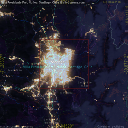
Analysis of Villa Presidente Frei, Ñuñoa, Santiago, Chile night lights 2016
Square area 10x10 km:
 67.48%
90-99
29.02%80-89
1.4%70-79
1.05%60-69
1.05%50-59
0%40-49
0%30-39
0%20-29
0%10-19
0%0-9
0%Square area 50x50 km:
17.26%90-99
10.34%80-89
3.4%70-79
3.85%60-69
6.08%50-59
6.14%40-49
4.42%30-39
4.27%20-29
5.93%10-19
7.17%0-9
31.15%Clear (daylight) street map image can be seen on geolist.org.
Map coordinates:
32° 52' 19.6" South, 71° 17' 0.1" West
33° 27' 38.5" South, 70° 34' 48.9" West
34° 2' 43" South, 69° 52' 37.6" West
Some cities around Villa Presidente Frei, Ñuñoa, Santiago, Chile sort by population:
• Santiago
6.3 km =3.9 mi,  273°
273°
• Puente Alto
16.8 km =10.4 mi,  178°
178°
• San Bernardo
18.3 km =11.4 mi,  217°
217°
• La Pintana
14.5 km =9 mi,  200°
200°
• Lo Prado
13.6 km =8.5 mi,  277°
277°
• Peñaflor
31.9 km =19.8 mi,  239°
239°
• Lampa
33.6 km =20.9 mi,  305°
305°
• Chicureo Abajo
20.8 km =12.9 mi,  340°
340°
7874740 (p: 15,000)
Sources (retrieved 2019-11-25):
» Earth at Night: Flat Maps 2012, 2016