Freire night lights from space
Night Light of Freire (Araucanía) from space (Chile) Src. Average luminocity for 10x10km area is 8.8571% and for 50x50km: 3.5784%.
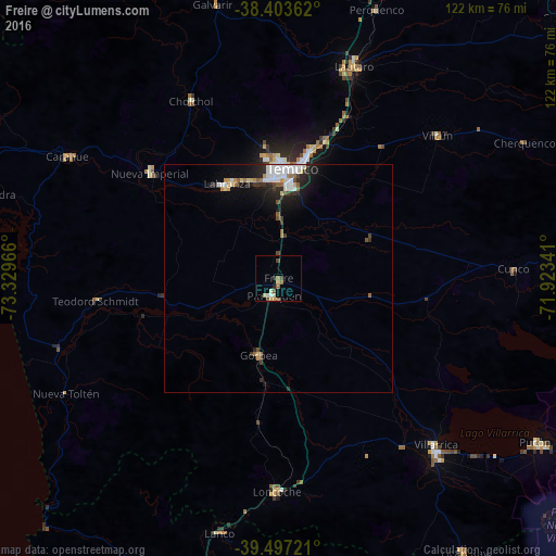
Analysis of Freire night lights 2016
Square area 10x10 km:
 0.32%
0.32%90-99
1.3%80-89
1.79%70-79
1.62%60-69
1.14%50-59
1.79%40-49
2.27%30-39
0.49%20-29
0.97%10-19
0%0-9
88.31%Square area 50x50 km:
0.68%90-99
0.68%80-89
0.38%70-79
0.36%60-69
0.23%50-59
0.44%40-49
0.4%30-39
0.4%20-29
1.01%10-19
2.17%0-9
93.26%Clear (daylight) street map image can be seen on geolist.org.
Map coordinates:
38° 24' 13" South, 73° 19' 46.8" West
38° 57' 9.1" South, 72° 37' 35.5" West
39° 29' 50" South, 71° 55' 24.3" West
Some cities around Freire sort by population:
• Temuco
23.8 km =14.8 mi,  5°
5°
• Villarrica
50.5 km =31.4 mi,  137°
137°
• Lautaro
49.7 km =30.9 mi,  19°
19°
• Nueva Imperial
36.3 km =22.6 mi,  309°
309°
• Loncoche
46.1 km =28.6 mi,  180°
180°
• Pitrufquén
3.9 km =2.4 mi,  193°
193°
• Carahue
53.5 km =33.2 mi,  300°
300°
• Vilcún
46.9 km =29.1 mi,  47°
47°
3889322 (p: 7,813)
Sources (retrieved 2019-11-25):
» Earth at Night: Flat Maps 2012, 2016