Botro night lights from space
Night Light of Botro (Vallée du Bandama) from space (Ivory Coast) Src. Average luminocity for 10x10km area is 5.4649% and for 50x50km: 1.4414%.
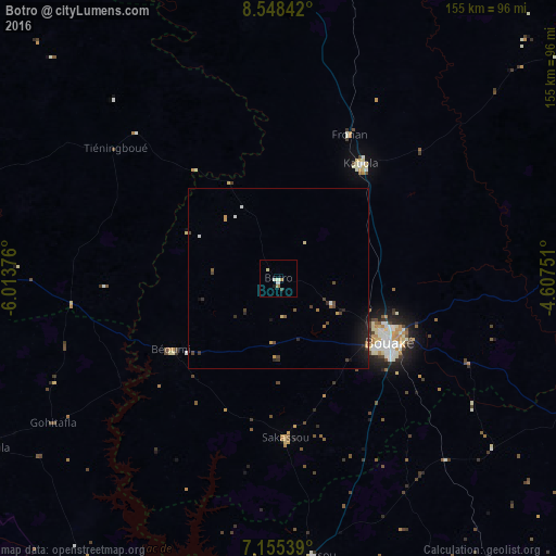
Analysis of Botro night lights 2016
Square area 10x10 km:
 0%
0%90-99
2.48%80-89
0.83%70-79
0%60-69
1.65%50-59
0%40-49
0.41%30-39
0.41%20-29
0.41%10-19
0.41%0-9
93.39%Square area 50x50 km:
0.03%90-99
0.2%80-89
0.1%70-79
0.2%60-69
0.18%50-59
0.13%40-49
0.4%30-39
0.23%20-29
0.46%10-19
1.08%0-9
96.99%Clear (daylight) street map image can be seen on geolist.org.
Map coordinates:
8° 32' 54.3" North, 6° 0' 49.5" West
7° 51' 9" North, 5° 18' 38.3" West
7° 9' 19.4" North, 4° 36' 27" West
Some cities around Botro sort by population:
• Bouaké
35.6 km =22.1 mi,  119°
119°
• Bouaflé
107.1 km =66.5 mi,  206°
206°
• Katiola
39.2 km =24.4 mi,  36°
36°
• Zuénoula
94.1 km =58.5 mi,  240°
240°
• Béoumi
35.8 km =22.2 mi, 236°
• Mankono
99.5 km =61.8 mi,  283°
283°
• Sakassou
44.3 km =27.5 mi,  177°
177°
• Dabakala
112.5 km =69.9 mi,  59°
59°
2290985 (p: 13,375)
Sources (retrieved 2019-11-25):
» Earth at Night: Flat Maps 2012, 2016