Villmergen night lights from space
Night Light of Villmergen (Aargau) from space (Switzerland) Src. Average luminocity for 10x10km area is 22.308% and for 50x50km: 18.4388%.
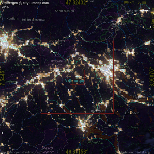
Analysis of Villmergen night lights 2016
Square area 10x10 km:
 0.89%
0.89%90-99
3.42%80-89
1.79%70-79
1.64%60-69
5.65%50-59
1.04%40-49
4.02%30-39
3.57%20-29
2.53%10-19
44.05%0-9
31.4%Square area 50x50 km:
2.68%90-99
2.96%80-89
1.23%70-79
1.68%60-69
2.67%50-59
2.51%40-49
2.92%30-39
2.58%20-29
5.07%10-19
16.84%0-9
58.85%Clear (daylight) street map image can be seen on geolist.org.
Map coordinates:
47° 49' 27.6" North, 7° 32' 40.2" East
47° 21' 0.3" North, 8° 14' 51.4" East
46° 52' 17.6" North, 8° 57' 2.7" East
Some cities around Villmergen sort by population:
• Wohlen
2.1 km =1.3 mi,  88°
88°
• Spreitenbach
12.1 km =7.5 mi,  48°
48°
• Neuenhof
12.6 km =7.8 mi,  28°
28°
• Reinach
11.5 km =7.1 mi,  205°
205°
• Lenzburg
6.9 km =4.3 mi,  308°
308°
• Gränichen
11 km =6.8 mi,  275°
275°
• Bremgarten
7.1 km =4.4 mi, 89°
• Muri
10.9 km =6.8 mi,  140°
140°
2658119 (p: 5,489)
Sources (retrieved 2019-11-25):
» Earth at Night: Flat Maps 2012, 2016